Wenquan geodata
Wenquan (Qinghai) is a seat of a fourth-order administrative division; located in China in Asia/Shanghai (GMT+8) time zone. In our database, there are 1268 cities with bigger population. Compared to other cities in China, 75.5% of cities are located further ↓South; 94.7% of cities are located further →East and 97.7% of cities have lower elevation than Wenquan. Note1


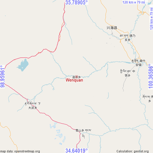
Wenquan GPS coordinates[2]
35° 12' 59.94" North, 99° 39' 45.828" East
| Map corner | latitude | longitude |
|---|---|---|
| Upper-left | 35.78905°, | 98.95961° |
| Center: | 35.21665°, | 99.66273° |
| Lower-right: | 34.64019°, | 100.36586° |
| Map W x H: | 127.7×127.7 km | = 79.3×79.3mi |
| max Lat: | 53.31946° ⇑24.5% North |
| Wenquan: | 35.21665° |
| min Lat: | ⇓75.5% South 18.22056° |
| min Long | Wenquan | max Long |
| 75.07348° | 99.66273° | 134.28917° |
| W 5.3%⇐ | ⇒94.7% E |
Elevation
Elevation of Wenquan is 3438 m = 11280 ft, and this is 2953.2 m = 9689 ft above average elevation for this country.
| Max E: |
5622 m = 18445 ft | 2.3% |
| Wenquan | 3438 m 11280 ft | |
| Avg. | 484.8 m = 1591 ft | |
Min E: |
-3 m = -10 ft | 97.7% |
See also: China elevation on elevation.city.
Geographical zone
Wenquan is located in North temperate zone (between Tropic of Cancer and the Arctic Circle). Distance of this Northern Tropic circle is 1309.8 km =813.9 mi to South.| Distance of | km | miles | from Wenquan |
|---|---|---|---|
| North Pole | 6091.3 | 3785 | to North |
| Arctic Circle | 3485.4 | 2165.7 | to North |
| Tropic Cancer | 1309.8 | 813.9 | to South |
| Equator | 3915.7 | 2433.1 | to South |


Nearby cities:
15 places around Wenquan: (largest is in red/bold)
• Bagou
67 km =41.6 mi,  84°
84°
• Gabasumdo
80.7 km =50.1 mi,  86°
86°
• Gomang
75.7 km =47 mi, 92°
• Heka
80.6 km =50.1 mi,  21°
21°
• Huashixia
79.2 km =49.2 mi,  261°
261°
• Longcang
37.7 km =23.4 mi, 79°
• Qushi’an
53.1 km =33 mi, 76°
• Sangdang
46.4 km =28.8 mi,  43°
43°
• Tanggan
68.1 km =42.3 mi, 91°
• Tangnaihai
53.8 km =33.4 mi,  52°
52°
• Xia Dawo
43.6 km =27.1 mi,  237°
237°
• Xiuma
63.5 km =39.5 mi,  106°
106°
• Xueshan
47.3 km =29.4 mi,  172°
172°
• Zhongtie
42.8 km =26.6 mi, 85°
• Ziketan
50.6 km =31.4 mi, 35°
Sources, notices
• [Note1] Compared only with cities in China existing in our database
• [Src1] Map data: © OpenStreetMap contributors (CC-BY-SA)
• [Src2] Other city data from geonames.org with taken over terms of usage.
• [Src3] Geographical zone / Annual Mean Temperature by Robert A. Rohde @ Wikipedia
