Huashixia geodata
Huashixia (Qinghai) is a seat of a fourth-order administrative division; located in China in Asia/Shanghai (GMT+8) time zone. In our database, there are 1268 cities with bigger population. Compared to other cities in China, 75.3% of cities are located further ↓South; 95.2% of cities are located further →East and 99.3% of cities have lower elevation than Huashixia. Note1


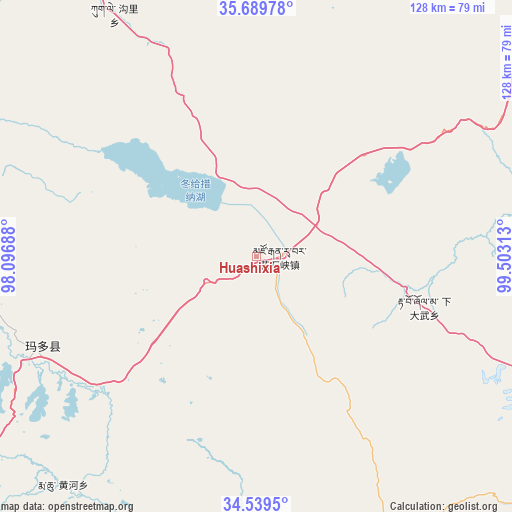
Huashixia GPS coordinates[2]
35° 7' 0.012" North, 98° 48' 0" East
| Map corner | latitude | longitude |
|---|---|---|
| Upper-left | 35.68978°, | 98.09688° |
| Center: | 35.11667°, | 98.8° |
| Lower-right: | 34.5395°, | 99.50313° |
| Map W x H: | 127.9×127.9 km | = 79.5×79.5mi |
| max Lat: | 53.31946° ⇑24.7% North |
| Huashixia: | 35.11667° |
| min Lat: | ⇓75.3% South 18.22056° |
| min Long | Huashixia | max Long |
| 75.07348° | 98.8° | 134.28917° |
| W 4.8%⇐ | ⇒95.2% E |
Elevation
Elevation of Huashixia is 4329 m = 14203 ft, and this is 3844.2 m = 12612 ft above average elevation for this country.
| Max E: |
5622 m = 18445 ft | 0.7% |
| Huashixia | 4329 m 14203 ft | |
| Avg. | 484.8 m = 1591 ft | |
Min E: |
-3 m = -10 ft | 99.3% |
See also: China elevation on elevation.city.
Geographical zone
Huashixia is located in North temperate zone (between Tropic of Cancer and the Arctic Circle). Distance of this Northern Tropic circle is 1298.7 km =807 mi to South.| Distance of | km | miles | from Huashixia |
|---|---|---|---|
| North Pole | 6102.5 | 3791.9 | to North |
| Arctic Circle | 3496.6 | 2172.7 | to North |
| Tropic Cancer | 1298.7 | 807 | to South |
| Equator | 3904.6 | 2426.2 | to South |


Nearby cities:
15 places around Huashixia: (largest is in red/bold)
• Changmahe
78.3 km =48.7 mi,  153°
153°
• Heihe
70.7 km =43.9 mi,  239°
239°
• Huanghe
75.4 km =46.9 mi,  215°
215°
• Kugri
69.9 km =43.4 mi,  329°
329°
• Longcang
116.9 km =72.6 mi,  81°
81°
• Machali
55.5 km =34.5 mi,  248°
248°
• Sangdang
118.8 km =73.8 mi,  67°
67°
• Wenquan
79.2 km =49.2 mi, 81°
• Xia Dawo
43.8 km =27.2 mi,  106°
106°
• Xiangjia
120.7 km =75 mi,  319°
319°
• Xueshan
91.7 km =57 mi, 112°
• Youyun
100.5 km =62.4 mi,  159°
159°
• Zhalinghu
81.2 km =50.5 mi,  267°
267°
• Zhongtie
122 km =75.8 mi, 83°
• Ziketan
119.7 km =74.4 mi,  64°
64°
Sources, notices
• [Note1] Compared only with cities in China existing in our database
• [Src1] Map data: © OpenStreetMap contributors (CC-BY-SA)
• [Src2] Other city data from geonames.org with taken over terms of usage.
• [Src3] Geographical zone / Annual Mean Temperature by Robert A. Rohde @ Wikipedia
