Kashgar geodata
Kashgar (Xinjiang) is a seat of a second-order administrative division; located in China in Asia/Urumqi (GMT+6) time zone. With population of 274,717 people, there are 185 cities with bigger population in this country. Compared to other cities in China, 84.5% of cities are located further ↓South; 100% of cities are located further →East and 89.3% of cities have lower elevation than Kashgar. Note1


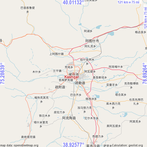
Kashgar GPS coordinates[2]
39° 28' 14.376" North, 75° 59' 22.236" East
| Map corner | latitude | longitude |
|---|---|---|
| Upper-left | 40.01132°, | 75.28639° |
| Center: | 39.47066°, | 75.98951° |
| Lower-right: | 38.92577°, | 76.69264° |
| Map W x H: | 120.7×120.7 km | = 75×75mi |
| max Lat: | 53.31946° ⇑15.5% North |
| Kashgar: | 39.47066° |
| min Lat: | ⇓84.5% South 18.22056° |
| min Long | Kashgar | max Long |
| 75.07348° | 75.98951° | 134.28917° |
| W 0%⇐ | ⇒100% E |
Elevation
Elevation of Kashgar is 1297 m = 4255 ft, and this is 812.2 m = 2665 ft above average elevation for this country.
| Max E: |
5622 m = 18445 ft | 10.7% |
| Kashgar | 1297 m 4255 ft | |
| Avg. | 484.8 m = 1591 ft | |
Min E: |
-3 m = -10 ft | 89.3% |
See also: Kashgar elevation on elevation.city.
Geographical zone
Kashgar is located in North temperate zone (between Tropic of Cancer and the Arctic Circle). Distance of this Northern Tropic circle is 1782.8 km =1107.8 mi to South.| Distance of | km | miles | from Kashgar |
|---|---|---|---|
| North Pole | 5618.3 | 3491 | to North |
| Arctic Circle | 3012.4 | 1871.8 | to North |
| Tropic Cancer | 1782.8 | 1107.8 | to South |
| Equator | 4388.7 | 2727 | to South |


Nearby cities:
15 places around Kashgar: (largest is in red/bold)
• Aiximan
50 km =31.1 mi,  115°
115°
• Aqqik
63.2 km =39.3 mi,  127°
127°
• Arzak
25.4 km =15.8 mi,  26°
26°
• Chengguan
63.7 km =39.6 mi,  166°
166°
• Jiangbazi
61.3 km =38.1 mi,  92°
92°
• Jiashi
64.7 km =40.2 mi, 87°
• Kezileboyi
48.8 km =30.3 mi,  101°
101°
• Longfu
59 km =36.7 mi, 174°
• Mangxing
63.2 km =39.3 mi,  163°
163°
• Qiaoleipan
60.4 km =37.5 mi, 169°
• Shule
9.2 km =5.7 mi,  145°
145°
• Tierimu
63.9 km =39.7 mi, 86°
• Xiaputule
53.9 km =33.5 mi, 90°
• Yekexianbaibazha
55.6 km =34.5 mi,  113°
113°
• Yingye’er
61.1 km =38 mi, 154°
In other languages:
- In Spanish: Kasgar
- In France: Kachgar
- In German: Kaschgar
- In Russian: Кашгар
- In Chinese: 喀什, 喀什市
Sources, notices
• [Note1] Compared only with cities in China existing in our database
• [Src1] Map data: © OpenStreetMap contributors (CC-BY-SA)
• [Src2] Other city data from geonames.org with taken over terms of usage.
• [Src3] Geographical zone / Annual Mean Temperature by Robert A. Rohde @ Wikipedia
