Coka geodata
Coka (Tibet) is a seat of a third-order administrative division; located in China in Asia/Shanghai (GMT+8) time zone. In our database, there are 1268 cities with bigger population. Compared to other cities in China, 53.9% of cities are located further ↓South; 96.2% of cities are located further →East and 98.1% of cities have lower elevation than Coka. Note1


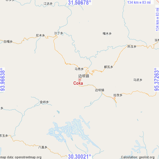
Coka GPS coordinates[2]
30° 54' 19.44" North, 94° 40' 10.2" East
| Map corner | latitude | longitude |
|---|---|---|
| Upper-left | 31.50678°, | 93.96638° |
| Center: | 30.9054°, | 94.6695° |
| Lower-right: | 30.30021°, | 95.37263° |
| Map W x H: | 134.2×134.2 km | = 83.4×83.4mi |
| max Lat: | 53.31946° ⇑46.1% North |
| Coka: | 30.9054° |
| min Lat: | ⇓53.9% South 18.22056° |
| min Long | Coka | max Long |
| 75.07348° | 94.6695° | 134.28917° |
| W 3.8%⇐ | ⇒96.2% E |
Elevation
Elevation of Coka is 3751 m = 12306 ft, and this is 3266.2 m = 10716 ft above average elevation for this country.
| Max E: |
5622 m = 18445 ft | 1.9% |
| Coka | 3751 m 12306 ft | |
| Avg. | 484.8 m = 1591 ft | |
Min E: |
-3 m = -10 ft | 98.1% |
See also: China elevation on elevation.city.
Geographical zone
Coka is located in North temperate zone (between Tropic of Cancer and the Arctic Circle). Distance of this Northern Tropic circle is 830.4 km =516 mi to South.| Distance of | km | miles | from Coka |
|---|---|---|---|
| North Pole | 6570.7 | 4082.8 | to North |
| Arctic Circle | 3964.8 | 2463.6 | to North |
| Tropic Cancer | 830.4 | 516 | to South |
| Equator | 3436.4 | 2135.3 | to South |


Nearby cities:
15 places around Coka: (largest is in red/bold)
• Banbar
17.9 km =11.1 mi,  117°
117°
• Domartang
4.2 km =2.6 mi,  26°
26°
• Garmo
46 km =28.6 mi, 30°
• Jaggong
72.3 km =44.9 mi,  251°
251°
• Jamda
69.6 km =43.2 mi,  337°
337°
• Jiling
34.6 km =21.5 mi,  235°
235°
• Marxog
8.9 km =5.5 mi,  353°
353°
• Mawu
49.7 km =30.9 mi,  89°
89°
• Nyinmo
49.5 km =30.8 mi,  320°
320°
• Paingar
68.6 km =42.6 mi,  298°
298°
• Reyu
52.5 km =32.6 mi,  57°
57°
• Rongbo
72.5 km =45 mi,  357°
357°
• Sechang
64.7 km =40.2 mi, 359°
• Shading
42.6 km =26.5 mi, 337°
• Towa
26.5 km =16.5 mi, 64°
Sources, notices
• [Note1] Compared only with cities in China existing in our database
• [Src1] Map data: © OpenStreetMap contributors (CC-BY-SA)
• [Src2] Other city data from geonames.org with taken over terms of usage.
• [Src3] Geographical zone / Annual Mean Temperature by Robert A. Rohde @ Wikipedia
