Sechang geodata
Sechang (Tibet) is a seat of a fourth-order administrative division; located in China in Asia/Shanghai (GMT+8) time zone. In our database, there are 1268 cities with bigger population. Compared to other cities in China, 58.3% of cities are located further ↓South; 96.2% of cities are located further →East and 98.5% of cities have lower elevation than Sechang. Note1


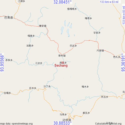
Sechang GPS coordinates[2]
31° 29' 12.624" North, 94° 39' 31.608" East
| Map corner | latitude | longitude |
|---|---|---|
| Upper-left | 32.08451°, | 93.95566° |
| Center: | 31.48684°, | 94.65878° |
| Lower-right: | 30.88533°, | 95.36191° |
| Map W x H: | 133.3×133.3 km | = 82.8×82.8mi |
| max Lat: | 53.31946° ⇑41.7% North |
| Sechang: | 31.48684° |
| min Lat: | ⇓58.3% South 18.22056° |
| min Long | Sechang | max Long |
| 75.07348° | 94.65878° | 134.28917° |
| W 3.8%⇐ | ⇒96.2% E |
Elevation
Elevation of Sechang is 3923 m = 12871 ft, and this is 3438.2 m = 11280 ft above average elevation for this country.
| Max E: |
5622 m = 18445 ft | 1.5% |
| Sechang | 3923 m 12871 ft | |
| Avg. | 484.8 m = 1591 ft | |
Min E: |
-3 m = -10 ft | 98.5% |
See also: China elevation on elevation.city.
Geographical zone
Sechang is located in North temperate zone (between Tropic of Cancer and the Arctic Circle). Distance of this Northern Tropic circle is 895.1 km =556.2 mi to South.| Distance of | km | miles | from Sechang |
|---|---|---|---|
| North Pole | 6506.1 | 4042.7 | to North |
| Arctic Circle | 3900.2 | 2423.5 | to North |
| Tropic Cancer | 895.1 | 556.2 | to South |
| Equator | 3501 | 2175.4 | to South |


Nearby cities:
15 places around Sechang: (largest is in red/bold)
• Chiduo
56.8 km =35.3 mi,  272°
272°
• Coka
64.7 km =40.2 mi,  179°
179°
• Domartang
61 km =37.9 mi, 177°
• Gamei
45.9 km =28.5 mi,  309°
309°
• Garmo
35.1 km =21.8 mi,  135°
135°
• Jamda
25.8 km =16 mi, 269°
• Jiaqin
40.5 km =25.2 mi,  295°
295°
• Marxog
55.8 km =34.7 mi, 180°
• Nyinmo
40.4 km =25.1 mi,  228°
228°
• Paingar
67.4 km =41.9 mi,  241°
241°
• Reyu
57.9 km =36 mi,  128°
128°
• Rongbo
8.2 km =5.1 mi,  342°
342°
• Shading
29.7 km =18.5 mi,  211°
211°
• Towa
58.9 km =36.6 mi,  154°
154°
• Ya’ngan
44.9 km =27.9 mi,  332°
332°
Sources, notices
• [Note1] Compared only with cities in China existing in our database
• [Src1] Map data: © OpenStreetMap contributors (CC-BY-SA)
• [Src2] Other city data from geonames.org with taken over terms of usage.
• [Src3] Geographical zone / Annual Mean Temperature by Robert A. Rohde @ Wikipedia
