Rongbo geodata
Rongbo (Tibet) is a seat of a fourth-order administrative division; located in China in Asia/Shanghai (GMT+8) time zone. In our database, there are 1268 cities with bigger population. Compared to other cities in China, 58.8% of cities are located further ↓South; 96.2% of cities are located further →East and 99.6% of cities have lower elevation than Rongbo. Note1


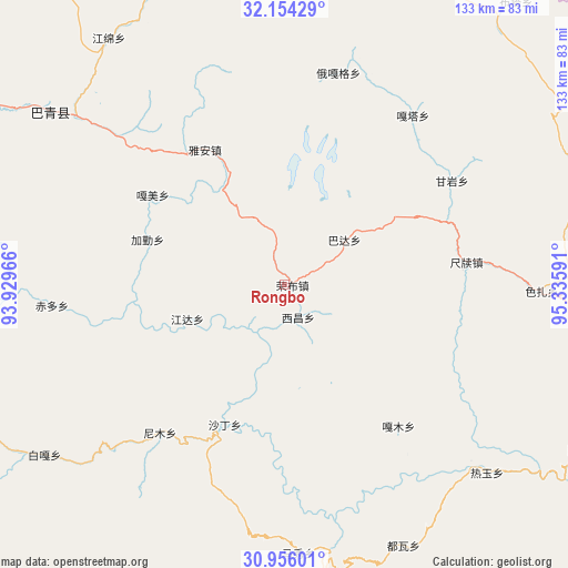
Rongbo GPS coordinates[2]
31° 33' 25.452" North, 94° 37' 58.008" East
| Map corner | latitude | longitude |
|---|---|---|
| Upper-left | 32.15429°, | 93.92966° |
| Center: | 31.55707°, | 94.63278° |
| Lower-right: | 30.95601°, | 95.33591° |
| Map W x H: | 133.2×133.2 km | = 82.8×82.8mi |
| max Lat: | 53.31946° ⇑41.2% North |
| Rongbo: | 31.55707° |
| min Lat: | ⇓58.8% South 18.22056° |
| min Long | Rongbo | max Long |
| 75.07348° | 94.63278° | 134.28917° |
| W 3.8%⇐ | ⇒96.2% E |
Elevation
Elevation of Rongbo is 4513 m = 14806 ft, and this is 4028.2 m = 13216 ft above average elevation for this country.
| Max E: |
5622 m = 18445 ft | 0.40000000000001% |
| Rongbo | 4513 m 14806 ft | |
| Avg. | 484.8 m = 1591 ft | |
Min E: |
-3 m = -10 ft | 99.6% |
See also: China elevation on elevation.city.
Geographical zone
Rongbo is located in North temperate zone (between Tropic of Cancer and the Arctic Circle). Distance of this Northern Tropic circle is 902.9 km =561 mi to South.| Distance of | km | miles | from Rongbo |
|---|---|---|---|
| North Pole | 6498.2 | 4037.8 | to North |
| Arctic Circle | 3892.4 | 2418.6 | to North |
| Tropic Cancer | 902.9 | 561 | to South |
| Equator | 3508.8 | 2180.3 | to South |


Nearby cities:
15 places around Rongbo: (largest is in red/bold)
• Chiduo
54.5 km =33.9 mi,  264°
264°
• Domartang
68.9 km =42.8 mi,  175°
175°
• Gamei
39.3 km =24.4 mi,  302°
302°
• Garmo
42.6 km =26.5 mi,  140°
140°
• Jamda
24.8 km =15.4 mi,  250°
250°
• Jiaqin
35.3 km =21.9 mi,  286°
286°
• Laxi
68.6 km =42.6 mi,  306°
306°
• Marxog
63.6 km =39.5 mi, 177°
• Nyinmo
44.3 km =27.5 mi,  219°
219°
• Paingar
69.4 km =43.1 mi,  234°
234°
• Reyu
64.9 km =40.3 mi,  132°
132°
• Sechang
8.2 km =5.1 mi,  162°
162°
• Shading
35.6 km =22.1 mi,  201°
201°
• Towa
67 km =41.6 mi, 155°
• Ya’ngan
36.8 km =22.9 mi,  329°
329°
Sources, notices
• [Note1] Compared only with cities in China existing in our database
• [Src1] Map data: © OpenStreetMap contributors (CC-BY-SA)
• [Src2] Other city data from geonames.org with taken over terms of usage.
• [Src3] Geographical zone / Annual Mean Temperature by Robert A. Rohde @ Wikipedia
