Turpan geodata
Turpan (Xinjiang) is a seat of a third-order administrative division; located in China in Asia/Urumqi (GMT+6) time zone. With population of 254,900 people, there are 196 cities with bigger population in this country. Compared to other cities in China, 91.9% of cities are located further ↓South; 97.6% of cities are located further →East and 73.3% of cities have higher elevation than Turpan. Note1


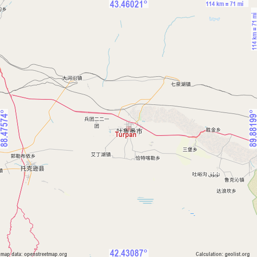
Turpan GPS coordinates[2]
42° 56' 51.684" North, 89° 10' 43.896" East
| Map corner | latitude | longitude |
|---|---|---|
| Upper-left | 43.46021°, | 88.47574° |
| Center: | 42.94769°, | 89.17886° |
| Lower-right: | 42.43087°, | 89.88199° |
| Map W x H: | 114.5×114.5 km | = 71.1×71.1mi |
| max Lat: | 53.31946° ⇑8.1% North |
| Turpan: | 42.94769° |
| min Lat: | ⇓91.9% South 18.22056° |
| min Long | Turpan | max Long |
| 75.07348° | 89.17886° | 134.28917° |
| W 2.4%⇐ | ⇒97.6% E |
Elevation
Elevation of Turpan is 41 m = 135 ft, and this is 443.8 m = 1456 ft below average elevation for this country.
| Max E: |
5622 m = 18445 ft | 73.3% |
| Avg. | 484.8 m = 1591 ft | |
| Turpan | 41 m = 135 ft | |
Min E: |
-3 m = -10 ft | 26.7% |
See also: Turpan elevation on elevation.city.
Geographical zone
Turpan is located in North temperate zone (between Tropic of Cancer and the Arctic Circle). Distance of this Northern Tropic circle is 2169.4 km =1348 mi to South.| Distance of | km | miles | from Turpan |
|---|---|---|---|
| North Pole | 5231.7 | 3250.8 | to North |
| Arctic Circle | 2625.8 | 1631.6 | to North |
| Tropic Cancer | 2169.4 | 1348 | to South |
| Equator | 4775.3 | 2967.2 | to South |


Nearby cities:
15 places around Turpan: (largest is in red/bold)
• Beiting
124.1 km =77.1 mi,  1°
1°
• Dabancheng
83.3 km =51.8 mi,  303°
303°
• Ewirgol
123.5 km =76.7 mi,  270°
270°
• Jimsar
115.5 km =71.8 mi,  355°
355°
• Jimusa’er
116.2 km =72.2 mi, 359°
• Laotai
132.7 km =82.5 mi,  348°
348°
• Mori
127.4 km =79.2 mi,  40°
40°
• Qingyanghu
127.4 km =79.2 mi, 352°
• Qitai
124.4 km =77.3 mi,  15°
15°
• Qoren
143 km =88.9 mi,  29°
29°
• Santai
129.1 km =80.2 mi, 349°
• Shanshan
84 km =52.2 mi,  96°
96°
• Toksun
47 km =29.2 mi,  248°
248°
• Xibeiwan
128.9 km =80.1 mi,  13°
13°
• Xidi
132.3 km =82.2 mi, 19°
Sources, notices
• [Note1] Compared only with cities in China existing in our database
• [Src1] Map data: © OpenStreetMap contributors (CC-BY-SA)
• [Src2] Other city data from geonames.org with taken over terms of usage.
• [Src3] Geographical zone / Annual Mean Temperature by Robert A. Rohde @ Wikipedia
