Huahai geodata
Huahai (Gansu) is a seat of a fourth-order administrative division; located in China in Asia/Shanghai (GMT+8) time zone. In our database, there are 1268 cities with bigger population. Compared to other cities in China, 87.5% of cities are located further ↓South; 95.5% of cities are located further →East and 88.9% of cities have lower elevation than Huahai. Note1


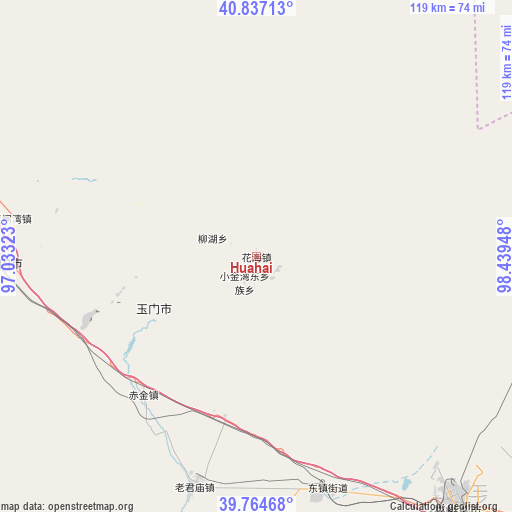
Huahai GPS coordinates[2]
40° 18' 10.908" North, 97° 44' 10.86" East
| Map corner | latitude | longitude |
|---|---|---|
| Upper-left | 40.83713°, | 97.03323° |
| Center: | 40.30303°, | 97.73635° |
| Lower-right: | 39.76468°, | 98.43948° |
| Map W x H: | 119.2×119.2 km | = 74.1×74.1mi |
| max Lat: | 53.31946° ⇑12.5% North |
| Huahai: | 40.30303° |
| min Lat: | ⇓87.5% South 18.22056° |
| min Long | Huahai | max Long |
| 75.07348° | 97.73635° | 134.28917° |
| W 4.5%⇐ | ⇒95.5% E |
Elevation
Elevation of Huahai is 1260 m = 4134 ft, and this is 775.2 m = 2543 ft above average elevation for this country.
| Max E: |
5622 m = 18445 ft | 11.1% |
| Huahai | 1260 m 4134 ft | |
| Avg. | 484.8 m = 1591 ft | |
Min E: |
-3 m = -10 ft | 88.9% |
See also: China elevation on elevation.city.
Geographical zone
Huahai is located in North temperate zone (between Tropic of Cancer and the Arctic Circle). Distance of this Northern Tropic circle is 1875.4 km =1165.3 mi to South.| Distance of | km | miles | from Huahai |
|---|---|---|---|
| North Pole | 5525.8 | 3433.6 | to North |
| Arctic Circle | 2919.9 | 1814.3 | to North |
| Tropic Cancer | 1875.4 | 1165.3 | to South |
| Equator | 4481.3 | 2784.5 | to South |


Nearby cities:
15 places around Huahai: (largest is in red/bold)
• Chijin
41.7 km =25.9 mi,  219°
219°
• Hedong
84.7 km =52.6 mi,  285°
285°
• Huangzhawan
57.8 km =35.9 mi,  278°
278°
• Jiayuguan
72 km =44.7 mi,  139°
139°
• Laojunmiao
52.2 km =32.4 mi,  180°
180°
• Liuhe
68.8 km =42.8 mi, 279°
• Qiwen
90.5 km =56.2 mi,  146°
146°
• Sandaogou
75.2 km =46.7 mi, 281°
• Wenshu
86.7 km =53.9 mi, 141°
• Xiaxihao
52.5 km =32.6 mi,  271°
271°
• Xiba
87.6 km =54.4 mi,  100°
100°
• Yaozhanzi
88.1 km =54.7 mi, 282°
• Yumen
45.5 km =28.3 mi, 267°
• Yumendong
57.6 km =35.8 mi,  166°
166°
• Yu’erhong
81.1 km =50.4 mi,  214°
214°
Sources, notices
• [Note1] Compared only with cities in China existing in our database
• [Src1] Map data: © OpenStreetMap contributors (CC-BY-SA)
• [Src2] Other city data from geonames.org with taken over terms of usage.
• [Src3] Geographical zone / Annual Mean Temperature by Robert A. Rohde @ Wikipedia
