Yumen geodata
Yumen (Gansu) is a seat of a third-order administrative division; located in China in Asia/Shanghai (GMT+8) time zone. In our database, there are 1268 cities with bigger population. Compared to other cities in China, 87.4% of cities are located further ↓South; 95.6% of cities are located further →East and 91.1% of cities have lower elevation than Yumen. Note1


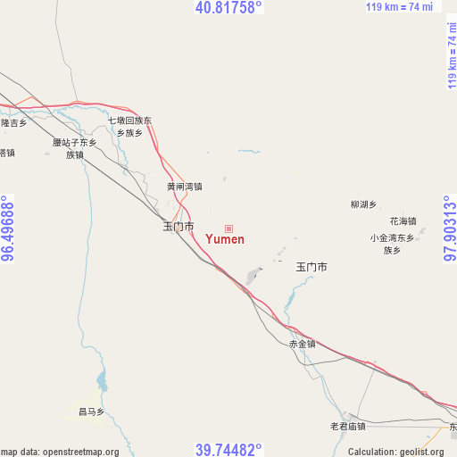
Yumen GPS coordinates[2]
40° 16' 59.988" North, 97° 12' 0" East
| Map corner | latitude | longitude |
|---|---|---|
| Upper-left | 40.81758°, | 96.49688° |
| Center: | 40.28333°, | 97.2° |
| Lower-right: | 39.74482°, | 97.90313° |
| Map W x H: | 119.3×119.3 km | = 74.1×74.1mi |
| max Lat: | 53.31946° ⇑12.6% North |
| Yumen: | 40.28333° |
| min Lat: | ⇓87.4% South 18.22056° |
| min Long | Yumen | max Long |
| 75.07348° | 97.2° | 134.28917° |
| W 4.4%⇐ | ⇒95.6% E |
Elevation
Elevation of Yumen is 1461 m = 4793 ft, and this is 976.2 m = 3203 ft above average elevation for this country.
| Max E: |
5622 m = 18445 ft | 8.9% |
| Yumen | 1461 m 4793 ft | |
| Avg. | 484.8 m = 1591 ft | |
Min E: |
-3 m = -10 ft | 91.1% |
See also: China elevation on elevation.city.
Geographical zone
Yumen is located in North temperate zone (between Tropic of Cancer and the Arctic Circle). Distance of this Northern Tropic circle is 1873.2 km =1164 mi to South.| Distance of | km | miles | from Yumen |
|---|---|---|---|
| North Pole | 5528 | 3434.9 | to North |
| Arctic Circle | 2922.1 | 1815.7 | to North |
| Tropic Cancer | 1873.2 | 1164 | to South |
| Equator | 4479.1 | 2783.2 | to South |


Nearby cities:
15 places around Yumen: (largest is in red/bold)
• Bulongji
62.2 km =38.6 mi,  296°
296°
• Changma
59.2 km =36.8 mi,  218°
218°
• Chijin
35.6 km =22.1 mi,  147°
147°
• Hedong
43.8 km =27.2 mi, 304°
• Huahai
45.5 km =28.3 mi,  87°
87°
• Huangzhawan
16.1 km =10 mi,  313°
313°
• Laojunmiao
67.6 km =42 mi,  137°
137°
• Liuhe
26.3 km =16.3 mi, 302°
• Qiaozi
84.8 km =52.7 mi,  273°
273°
• Sandaogou
33 km =20.5 mi, 300°
• Tashi
103.5 km =64.3 mi, 268°
• Xiaxihao
8 km =5 mi, 299°
• Yaozhanzi
45.9 km =28.5 mi, 297°
• Yumendong
80.2 km =49.8 mi,  132°
132°
• Yu’erhong
64.8 km =40.3 mi,  180°
180°
Sources, notices
• [Note1] Compared only with cities in China existing in our database
• [Src1] Map data: © OpenStreetMap contributors (CC-BY-SA)
• [Src2] Other city data from geonames.org with taken over terms of usage.
• [Src3] Geographical zone / Annual Mean Temperature by Robert A. Rohde @ Wikipedia
