Liuhe geodata
Liuhe (Gansu) is a seat of a fourth-order administrative division; located in China in Asia/Shanghai (GMT+8) time zone. In our database, there are 1268 cities with bigger population. Compared to other cities in China, 87.8% of cities are located further ↓South; 95.7% of cities are located further →East and 90.9% of cities have lower elevation than Liuhe. Note1


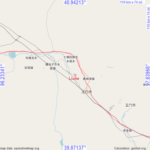
Liuhe GPS coordinates[2]
40° 24' 31.968" North, 96° 56' 11.508" East
| Map corner | latitude | longitude |
|---|---|---|
| Upper-left | 40.94213°, | 96.23341° |
| Center: | 40.40888°, | 96.93653° |
| Lower-right: | 39.87137°, | 97.63966° |
| Map W x H: | 119.1×119.1 km | = 74×74mi |
| max Lat: | 53.31946° ⇑12.2% North |
| Liuhe: | 40.40888° |
| min Lat: | ⇓87.8% South 18.22056° |
| min Long | Liuhe | max Long |
| 75.07348° | 96.93653° | 134.28917° |
| W 4.3%⇐ | ⇒95.7% E |
Elevation
Elevation of Liuhe is 1442 m = 4731 ft, and this is 957.2 m = 3140 ft above average elevation for this country.
| Max E: |
5622 m = 18445 ft | 9.1% |
| Liuhe | 1442 m 4731 ft | |
| Avg. | 484.8 m = 1591 ft | |
Min E: |
-3 m = -10 ft | 90.9% |
See also: China elevation on elevation.city.
Geographical zone
Liuhe is located in North temperate zone (between Tropic of Cancer and the Arctic Circle). Distance of this Northern Tropic circle is 1887.1 km =1172.6 mi to South.| Distance of | km | miles | from Liuhe |
|---|---|---|---|
| North Pole | 5514 | 3426.2 | to North |
| Arctic Circle | 2908.1 | 1807 | to North |
| Tropic Cancer | 1887.1 | 1172.6 | to South |
| Equator | 4493 | 2791.8 | to South |


Nearby cities:
15 places around Liuhe: (largest is in red/bold)
• Bulongji
36.1 km =22.4 mi,  292°
292°
• Changma
62 km =38.5 mi,  193°
193°
• Chijin
60.5 km =37.6 mi,  136°
136°
• Hedong
17.5 km =10.9 mi,  307°
307°
• Huahai
68.8 km =42.8 mi,  99°
99°
• Huangzhawan
11 km =6.8 mi, 104°
• Laojunmiao
93.2 km =57.9 mi,  133°
133°
• Qiaozi
63 km =39.1 mi,  261°
261°
• Sandaogou
6.7 km =4.2 mi,  295°
295°
• Tashi
82.7 km =51.4 mi, 258°
• Xiaxihao
18.3 km =11.4 mi,  123°
123°
• Yaozhanzi
19.7 km =12.2 mi, 292°
• Yuanquan
96.7 km =60.1 mi,  276°
276°
• Yumen
26.3 km =16.3 mi, 122°
• Yu’erhong
81.8 km =50.8 mi,  164°
164°
Sources, notices
• [Note1] Compared only with cities in China existing in our database
• [Src1] Map data: © OpenStreetMap contributors (CC-BY-SA)
• [Src2] Other city data from geonames.org with taken over terms of usage.
• [Src3] Geographical zone / Annual Mean Temperature by Robert A. Rohde @ Wikipedia
