Changji geodata
Changji (Xinjiang) is a seat of a second-order administrative division; located in China in Asia/Urumqi (GMT+6) time zone. With population of 198,776 people, there are 231 cities with bigger population in this country. Compared to other cities in China, 92.8% of cities are located further ↓South; 98.1% of cities are located further →East and 77.2% of cities have lower elevation than Changji. Note1


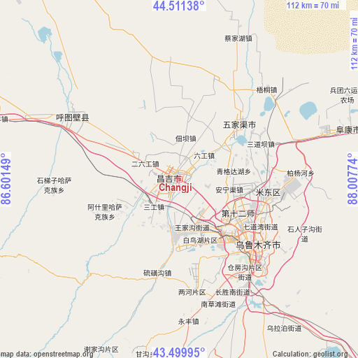
Changji GPS coordinates[2]
44° 0' 28.152" North, 87° 18' 16.596" East
| Map corner | latitude | longitude |
|---|---|---|
| Upper-left | 44.51138°, | 86.60149° |
| Center: | 44.00782°, | 87.30461° |
| Lower-right: | 43.49995°, | 88.00774° |
| Map W x H: | 112.5×112.5 km | = 69.9×69.9mi |
| max Lat: | 53.31946° ⇑7.2% North |
| Changji: | 44.00782° |
| min Lat: | ⇓92.8% South 18.22056° |
| min Long | Changji | max Long |
| 75.07348° | 87.30461° | 134.28917° |
| W 1.9%⇐ | ⇒98.1% E |
Elevation
Elevation of Changji is 581 m = 1906 ft, and this is 96.2 m = 316 ft above average elevation for this country.
| Max E: |
5622 m = 18445 ft | 22.8% |
| Changji | 581 m 1906 ft | |
| Avg. | 484.8 m = 1591 ft | |
Min E: |
-3 m = -10 ft | 77.2% |
See also: Changji elevation on elevation.city.
Geographical zone
Changji is located in North temperate zone (between Tropic of Cancer and the Arctic Circle). Distance of this Northern Tropic circle is 2287.3 km =1421.3 mi to South.| Distance of | km | miles | from Changji |
|---|---|---|---|
| North Pole | 5113.9 | 3177.6 | to North |
| Arctic Circle | 2508 | 1558.4 | to North |
| Tropic Cancer | 2287.3 | 1421.3 | to South |
| Equator | 4893.2 | 3040.5 | to South |


Nearby cities:
15 places around Changji: (largest is in red/bold)
• Anningqu
18.5 km =11.5 mi,  98°
98°
• Beijinglu
29.1 km =18.1 mi,  131°
131°
• Bingchao
10.8 km =6.7 mi,  31°
31°
• Changshanzi
26.2 km =16.3 mi,  69°
69°
• Daxiqu
11.2 km =7 mi,  348°
348°
• Dianba
13.1 km =8.1 mi,  8°
8°
• Diwopu
19.9 km =12.4 mi, 134°
• Ergong
27.4 km =17 mi, 129°
• Erliugong
11.8 km =7.3 mi,  295°
295°
• Gumudi
30.1 km =18.7 mi, 101°
• Huoche Xizhan
17.8 km =11.1 mi,  148°
148°
• Liugong
10.9 km =6.8 mi,  45°
45°
• Sandaoba
28.6 km =17.8 mi,  62°
62°
• Yangmaogong
28 km =17.4 mi, 53°
• Yushugou
14.7 km =9.1 mi,  287°
287°
Sources, notices
• [Note1] Compared only with cities in China existing in our database
• [Src1] Map data: © OpenStreetMap contributors (CC-BY-SA)
• [Src2] Other city data from geonames.org with taken over terms of usage.
• [Src3] Geographical zone / Annual Mean Temperature by Robert A. Rohde @ Wikipedia
