Gumudi geodata
Gumudi (Xinjiang) is a seat of a third-order administrative division; located in China in Asia/Urumqi (GMT+6) time zone. In our database, there are 1268 cities with bigger population. Compared to other cities in China, 92.7% of cities are located further ↓South; 98% of cities are located further →East and 78.5% of cities have lower elevation than Gumudi. Note1


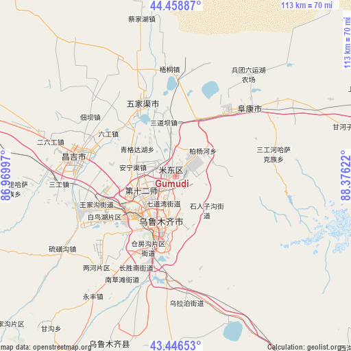
Gumudi GPS coordinates[2]
43° 57' 17.496" North, 87° 40' 23.124" East
| Map corner | latitude | longitude |
|---|---|---|
| Upper-left | 44.45887°, | 86.96997° |
| Center: | 43.95486°, | 87.67309° |
| Lower-right: | 43.44653°, | 88.37622° |
| Map W x H: | 112.6×112.6 km | = 70×70mi |
| max Lat: | 53.31946° ⇑7.3% North |
| Gumudi: | 43.95486° |
| min Lat: | ⇓92.7% South 18.22056° |
| min Long | Gumudi | max Long |
| 75.07348° | 87.67309° | 134.28917° |
| W 2%⇐ | ⇒98% E |
Elevation
Elevation of Gumudi is 633 m = 2077 ft, and this is 148.2 m = 486 ft above average elevation for this country.
| Max E: |
5622 m = 18445 ft | 21.5% |
| Gumudi | 633 m 2077 ft | |
| Avg. | 484.8 m = 1591 ft | |
Min E: |
-3 m = -10 ft | 78.5% |
See also: China elevation on elevation.city.
Geographical zone
Gumudi is located in North temperate zone (between Tropic of Cancer and the Arctic Circle). Distance of this Northern Tropic circle is 2281.4 km =1417.6 mi to South.| Distance of | km | miles | from Gumudi |
|---|---|---|---|
| North Pole | 5119.7 | 3181.2 | to North |
| Arctic Circle | 2513.9 | 1562.1 | to North |
| Tropic Cancer | 2281.4 | 1417.6 | to South |
| Equator | 4887.3 | 3036.8 | to South |


Nearby cities:
15 places around Gumudi: (largest is in red/bold)
• Anningqu
11.6 km =7.2 mi,  285°
285°
• Baiyanghe
10.2 km =6.3 mi,  45°
45°
• Beijinglu
15.5 km =9.6 mi,  210°
210°
• Changshanzi
15.7 km =9.8 mi,  341°
341°
• Diwopu
17.2 km =10.7 mi,  242°
242°
• Ergong
14.4 km =8.9 mi,  216°
216°
• Huoche Xizhan
22.3 km =13.9 mi,  245°
245°
• Lucaogou
13.2 km =8.2 mi,  137°
137°
• Sandaoba
19.7 km =12.2 mi,  347°
347°
• Shuimogou
14.3 km =8.9 mi,  191°
191°
• Tiechanggou
9.8 km =6.1 mi,  115°
115°
• Xingfulu
19.4 km =12.1 mi, 188°
• Yangmaogong
23.7 km =14.7 mi, 342°
• Yangzi Jianglu
21.3 km =13.2 mi,  198°
198°
• Ürümqi
18.1 km =11.2 mi, 198°
Sources, notices
• [Note1] Compared only with cities in China existing in our database
• [Src1] Map data: © OpenStreetMap contributors (CC-BY-SA)
• [Src2] Other city data from geonames.org with taken over terms of usage.
• [Src3] Geographical zone / Annual Mean Temperature by Robert A. Rohde @ Wikipedia
