Yangmaogong geodata
Yangmaogong (Xinjiang) is a seat of a fourth-order administrative division; located in China in Asia/Urumqi (GMT+6) time zone. In our database, there are 1268 cities with bigger population. Compared to other cities in China, 93% of cities are located further ↓South; 98% of cities are located further →East and 72.9% of cities have lower elevation than Yangmaogong. Note1


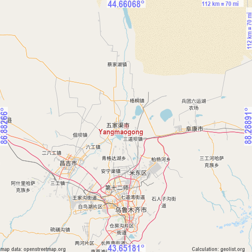
Yangmaogong GPS coordinates[2]
44° 9' 30.24" North, 87° 35' 8.808" East
| Map corner | latitude | longitude |
|---|---|---|
| Upper-left | 44.66068°, | 86.88266° |
| Center: | 44.1584°, | 87.58578° |
| Lower-right: | 43.65181°, | 88.28891° |
| Map W x H: | 112.2×112.2 km | = 69.7×69.7mi |
| max Lat: | 53.31946° ⇑7% North |
| Yangmaogong: | 44.1584° |
| min Lat: | ⇓93% South 18.22056° |
| min Long | Yangmaogong | max Long |
| 75.07348° | 87.58578° | 134.28917° |
| W 2%⇐ | ⇒98% E |
Elevation
Elevation of Yangmaogong is 474 m = 1555 ft, and this is 10.8 m = 35 ft below average elevation for this country.
| Max E: |
5622 m = 18445 ft | 27.1% |
| Avg. | 484.8 m = 1591 ft | |
| Yangmaogong | 474 m = 1555 ft | |
Min E: |
-3 m = -10 ft | 72.9% |
See also: China elevation on elevation.city.
Geographical zone
Yangmaogong is located in North temperate zone (between Tropic of Cancer and the Arctic Circle). Distance of this Northern Tropic circle is 2304 km =1431.6 mi to South.| Distance of | km | miles | from Yangmaogong |
|---|---|---|---|
| North Pole | 5097.1 | 3167.2 | to North |
| Arctic Circle | 2491.2 | 1548 | to North |
| Tropic Cancer | 2304 | 1431.6 | to South |
| Equator | 4910 | 3050.9 | to South |


Nearby cities:
15 places around Yangmaogong: (largest is in red/bold)
• Anningqu
19.9 km =12.4 mi,  192°
192°
• Baiyanghe
21.1 km =13.1 mi,  137°
137°
• Bingchao
18.4 km =11.4 mi,  245°
245°
• Changji
28 km =17.4 mi,  233°
233°
• Changshanzi
8 km =5 mi,  164°
164°
• Daxiqu
25.3 km =15.7 mi,  256°
256°
• Dianba
20.8 km =12.9 mi, 259°
• Diwopu
31.7 km =19.7 mi, 194°
• Ergong
34.3 km =21.3 mi,  182°
182°
• Fukang
31 km =19.3 mi,  89°
89°
• Gumudi
23.7 km =14.7 mi, 162°
• Huoche Xizhan
34.5 km =21.4 mi,  202°
202°
• Liugong
17.3 km =10.7 mi,  238°
238°
• Sandaoba
4.4 km =2.7 mi, 140°
• Tiechanggou
31.2 km =19.4 mi,  149°
149°
Sources, notices
• [Note1] Compared only with cities in China existing in our database
• [Src1] Map data: © OpenStreetMap contributors (CC-BY-SA)
• [Src2] Other city data from geonames.org with taken over terms of usage.
• [Src3] Geographical zone / Annual Mean Temperature by Robert A. Rohde @ Wikipedia
