Tiechanggou geodata
Tiechanggou (Xinjiang) is a seat of a fourth-order administrative division; located in China in Asia/Urumqi (GMT+6) time zone. In our database, there are 1268 cities with bigger population. Compared to other cities in China, 92.6% of cities are located further ↓South; 97.9% of cities are located further →East and 83.2% of cities have lower elevation than Tiechanggou. Note1


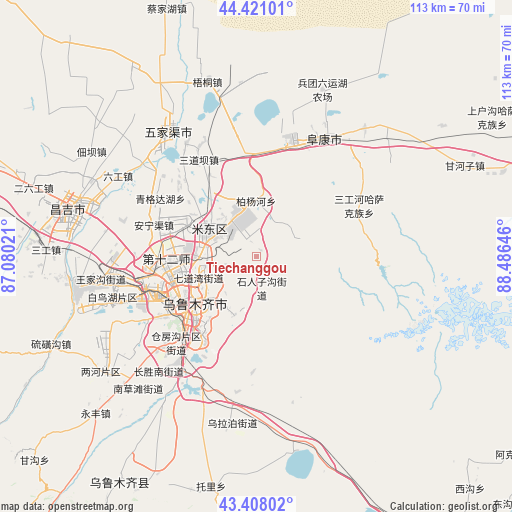
Tiechanggou GPS coordinates[2]
43° 55' 0.012" North, 87° 46' 59.988" East
| Map corner | latitude | longitude |
|---|---|---|
| Upper-left | 44.42101°, | 87.08021° |
| Center: | 43.91667°, | 87.78333° |
| Lower-right: | 43.40802°, | 88.48646° |
| Map W x H: | 112.6×112.6 km | = 70×70mi |
| max Lat: | 53.31946° ⇑7.4% North |
| Tiechanggou: | 43.91667° |
| min Lat: | ⇓92.6% South 18.22056° |
| min Long | Tiechanggou | max Long |
| 75.07348° | 87.78333° | 134.28917° |
| W 2.1%⇐ | ⇒97.9% E |
Elevation
Elevation of Tiechanggou is 864 m = 2835 ft, and this is 379.2 m = 1244 ft above average elevation for this country.
| Max E: |
5622 m = 18445 ft | 16.8% |
| Tiechanggou | 864 m 2835 ft | |
| Avg. | 484.8 m = 1591 ft | |
Min E: |
-3 m = -10 ft | 83.2% |
See also: China elevation on elevation.city.
Geographical zone
Tiechanggou is located in North temperate zone (between Tropic of Cancer and the Arctic Circle). Distance of this Northern Tropic circle is 2277.2 km =1415 mi to South.| Distance of | km | miles | from Tiechanggou |
|---|---|---|---|
| North Pole | 5124 | 3183.9 | to North |
| Arctic Circle | 2518.1 | 1564.7 | to North |
| Tropic Cancer | 2277.2 | 1415 | to South |
| Equator | 4883.1 | 3034.2 | to South |


Nearby cities:
15 places around Tiechanggou: (largest is in red/bold)
• Anningqu
21.3 km =13.2 mi,  290°
290°
• Baiyanghe
11.5 km =7.1 mi,  352°
352°
• Beijinglu
18.9 km =11.7 mi,  241°
241°
• Changshanzi
23.5 km =14.6 mi,  324°
324°
• Diwopu
24.3 km =15.1 mi,  261°
261°
• Ergong
18.9 km =11.7 mi,  246°
246°
• Fukang
30.9 km =19.2 mi,  29°
29°
• Gumudi
9.8 km =6.1 mi,  295°
295°
• Huoche Xizhan
29.5 km =18.3 mi, 260°
• Lucaogou
5.6 km =3.5 mi,  180°
180°
• Sandaoba
26.9 km =16.7 mi,  331°
331°
• Shuimogou
15.2 km =9.4 mi,  229°
229°
• Xingfulu
19 km =11.8 mi,  218°
218°
• Yangzi Jianglu
22.3 km =13.9 mi, 224°
• Ürümqi
19.5 km =12.1 mi, 228°
Sources, notices
• [Note1] Compared only with cities in China existing in our database
• [Src1] Map data: © OpenStreetMap contributors (CC-BY-SA)
• [Src2] Other city data from geonames.org with taken over terms of usage.
• [Src3] Geographical zone / Annual Mean Temperature by Robert A. Rohde @ Wikipedia
