Lucaogou geodata
Lucaogou (Xinjiang) is a seat of a fourth-order administrative division; located in China in Asia/Urumqi (GMT+6) time zone. In our database, there are 1268 cities with bigger population. Compared to other cities in China, 92.6% of cities are located further ↓South; 97.9% of cities are located further →East and 83.6% of cities have lower elevation than Lucaogou. Note1


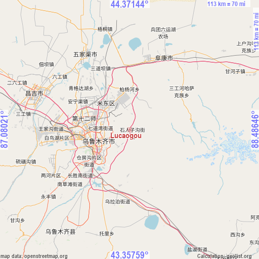
Lucaogou GPS coordinates[2]
43° 52' 0.012" North, 87° 46' 59.988" East
| Map corner | latitude | longitude |
|---|---|---|
| Upper-left | 44.37144°, | 87.08021° |
| Center: | 43.86667°, | 87.78333° |
| Lower-right: | 43.35759°, | 88.48646° |
| Map W x H: | 112.7×112.7 km | = 70×70mi |
| max Lat: | 53.31946° ⇑7.4% North |
| Lucaogou: | 43.86667° |
| min Lat: | ⇓92.6% South 18.22056° |
| min Long | Lucaogou | max Long |
| 75.07348° | 87.78333° | 134.28917° |
| W 2.1%⇐ | ⇒97.9% E |
Elevation
Elevation of Lucaogou is 889 m = 2917 ft, and this is 404.2 m = 1326 ft above average elevation for this country.
| Max E: |
5622 m = 18445 ft | 16.4% |
| Lucaogou | 889 m 2917 ft | |
| Avg. | 484.8 m = 1591 ft | |
Min E: |
-3 m = -10 ft | 83.6% |
See also: China elevation on elevation.city.
Geographical zone
Lucaogou is located in North temperate zone (between Tropic of Cancer and the Arctic Circle). Distance of this Northern Tropic circle is 2271.6 km =1411.5 mi to South.| Distance of | km | miles | from Lucaogou |
|---|---|---|---|
| North Pole | 5129.5 | 3187.3 | to North |
| Arctic Circle | 2523.7 | 1568.2 | to North |
| Tropic Cancer | 2271.6 | 1411.5 | to South |
| Equator | 4877.5 | 3030.7 | to South |


Nearby cities:
15 places around Lucaogou: (largest is in red/bold)
• Anningqu
23.9 km =14.9 mi,  302°
302°
• Baiyanghe
17 km =10.6 mi,  354°
354°
• Beijinglu
17 km =10.6 mi,  257°
257°
• Changshanzi
28.2 km =17.5 mi,  330°
330°
• Diwopu
24.1 km =15 mi,  274°
274°
• Ergong
17.5 km =10.9 mi, 263°
• Fukang
35.9 km =22.3 mi,  25°
25°
• Gumudi
13.2 km =8.2 mi,  317°
317°
• Huoche Xizhan
29.1 km =18.1 mi, 271°
• Sandaoba
31.8 km =19.8 mi,  335°
335°
• Shuimogou
12.4 km =7.7 mi,  249°
249°
• Tiechanggou
5.6 km =3.5 mi,  0°
0°
• Xingfulu
15 km =9.3 mi,  231°
231°
• Yangzi Jianglu
18.7 km =11.6 mi,  236°
236°
• Ürümqi
16.4 km =10.2 mi, 243°
Sources, notices
• [Note1] Compared only with cities in China existing in our database
• [Src1] Map data: © OpenStreetMap contributors (CC-BY-SA)
• [Src2] Other city data from geonames.org with taken over terms of usage.
• [Src3] Geographical zone / Annual Mean Temperature by Robert A. Rohde @ Wikipedia
