Ürümqi geodata
Ürümqi (Xinjiang) is a seat of a first-order administrative division; located in China in Asia/Urumqi (GMT+6) time zone. With population of 3,029,372 people, there are 37 cities with bigger population in this country. Compared to other cities in China, 92.5% of cities are located further ↓South; 98% of cities are located further →East and 83.2% of cities have lower elevation than Ürümqi. Note1


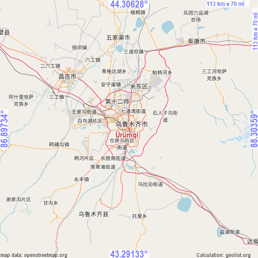
Ürümqi GPS coordinates[2]
43° 48' 3.456" North, 87° 36' 1.656" East
| Map corner | latitude | longitude |
|---|---|---|
| Upper-left | 44.30628°, | 86.89734° |
| Center: | 43.80096°, | 87.60046° |
| Lower-right: | 43.29133°, | 88.30359° |
| Map W x H: | 112.9×112.9 km | = 70.2×70.2mi |
| max Lat: | 53.31946° ⇑7.5% North |
| Ürümqi: | 43.80096° |
| min Lat: | ⇓92.5% South 18.22056° |
| min Long | Ürümqi | max Long |
| 75.07348° | 87.60046° | 134.28917° |
| W 2%⇐ | ⇒98% E |
Elevation
Elevation of Ürümqi is 862 m = 2828 ft, and this is 377.2 m = 1238 ft above average elevation for this country.
| Max E: |
5622 m = 18445 ft | 16.8% |
| Ürümqi | 862 m 2828 ft | |
| Avg. | 484.8 m = 1591 ft | |
Min E: |
-3 m = -10 ft | 83.2% |
See also: Ürümqi elevation on elevation.city.
Geographical zone
Ürümqi is located in North temperate zone (between Tropic of Cancer and the Arctic Circle). Distance of this Northern Tropic circle is 2264.3 km =1407 mi to South.| Distance of | km | miles | from Ürümqi |
|---|---|---|---|
| North Pole | 5136.9 | 3191.9 | to North |
| Arctic Circle | 2531 | 1572.7 | to North |
| Tropic Cancer | 2264.3 | 1407 | to South |
| Equator | 4870.2 | 3026.2 | to South |


Nearby cities:
15 places around Ürümqi: (largest is in red/bold)
• Anningqu
21 km =13 mi,  345°
345°
• Baiyanghe
27.6 km =17.1 mi,  28°
28°
• Beijinglu
4.2 km =2.6 mi,  332°
332°
• Changji
33 km =20.5 mi,  314°
314°
• Changshanzi
32 km =19.9 mi,  1°
1°
• Diwopu
13.1 km =8.1 mi, 314°
• Ergong
6.1 km =3.8 mi, 333°
• Gumudi
18.1 km =11.2 mi,  18°
18°
• Huoche Xizhan
16.4 km =10.2 mi,  298°
298°
• Liugong
34.5 km =21.4 mi, 332°
• Lucaogou
16.4 km =10.2 mi,  63°
63°
• Shuimogou
4.3 km =2.7 mi,  44°
44°
• Tiechanggou
19.5 km =12.1 mi,  48°
48°
• Xingfulu
3.6 km =2.2 mi,  125°
125°
• Yangzi Jianglu
3.2 km =2 mi,  196°
196°
Sources, notices
• [Note1] Compared only with cities in China existing in our database
• [Src1] Map data: © OpenStreetMap contributors (CC-BY-SA)
• [Src2] Other city data from geonames.org with taken over terms of usage.
• [Src3] Geographical zone / Annual Mean Temperature by Robert A. Rohde @ Wikipedia
