Kokagax geodata
Kokagax (Xinjiang) is a seat of a fourth-order administrative division; located in China in Asia/Urumqi (GMT+6) time zone. In our database, there are 1268 cities with bigger population. Compared to other cities in China, 97% of cities are located further ↓South; 97.9% of cities are located further →East and 75% of cities have lower elevation than Kokagax. Note1


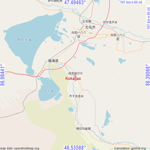
Kokagax GPS coordinates[2]
47° 1' 2.676" North, 87° 41' 15.108" East
| Map corner | latitude | longitude |
|---|---|---|
| Upper-left | 47.49463°, | 86.98441° |
| Center: | 47.01741°, | 87.68753° |
| Lower-right: | 46.53588°, | 88.39066° |
| Map W x H: | 106.6×106.6 km | = 66.2×66.2mi |
| max Lat: | 53.31946° ⇑3% North |
| Kokagax: | 47.01741° |
| min Lat: | ⇓97% South 18.22056° |
| min Long | Kokagax | max Long |
| 75.07348° | 87.68753° | 134.28917° |
| W 2.1%⇐ | ⇒97.9% E |
Elevation
Elevation of Kokagax is 521 m = 1709 ft, and this is 36.2 m = 119 ft above average elevation for this country.
| Max E: |
5622 m = 18445 ft | 25% |
| Kokagax | 521 m 1709 ft | |
| Avg. | 484.8 m = 1591 ft | |
Min E: |
-3 m = -10 ft | 75% |
See also: China elevation on elevation.city.
Geographical zone
Kokagax is located in North temperate zone (between Tropic of Cancer and the Arctic Circle). Distance of this North polar circle is 2173.3 km =1350.4 mi to North.| Distance of | km | miles | from Kokagax |
|---|---|---|---|
| North Pole | 4779.2 | 2969.7 | to North |
| Arctic Circle | 2173.3 | 1350.4 | to North |
| Tropic Cancer | 2621.9 | 1629.2 | to South |
| Equator | 5227.8 | 3248.4 | to South |


Nearby cities:
15 places around Kokagax: (largest is in red/bold)
• Alakak
82.1 km =51 mi,  349°
349°
• Awiytan
83.3 km =51.8 mi,  19°
19°
• A’erda
18.7 km =11.6 mi,  313°
313°
• Balbagay
55.8 km =34.7 mi,  4°
4°
• Beitun
38.6 km =24 mi, 15°
• Fuhai
18.2 km =11.3 mi,  304°
304°
• Haramgai
40.6 km =25.2 mi,  170°
170°
• Hongdun
88.2 km =54.8 mi,  26°
26°
• Jetaral
20.4 km =12.7 mi, 295°
• Kalaxilike
81 km =50.3 mi, 347°
• Kostik
89.7 km =55.7 mi,  342°
342°
• Qiganjidie
17.2 km =10.7 mi, 172°
• Sa’erhusong
54.1 km =33.6 mi, 348°
• Xemirxek
89.1 km =55.4 mi,  13°
13°
• Xirikxiy
45.1 km =28 mi, 33°
Sources, notices
• [Note1] Compared only with cities in China existing in our database
• [Src1] Map data: © OpenStreetMap contributors (CC-BY-SA)
• [Src2] Other city data from geonames.org with taken over terms of usage.
• [Src3] Geographical zone / Annual Mean Temperature by Robert A. Rohde @ Wikipedia
