Xirikxiy geodata
Xirikxiy (Xinjiang) is a seat of a fourth-order administrative division; located in China in Asia/Urumqi (GMT+6) time zone. In our database, there are 1268 cities with bigger population. Compared to other cities in China, 97.7% of cities are located further ↓South; 97.9% of cities are located further →East and 75.4% of cities have lower elevation than Xirikxiy. Note1


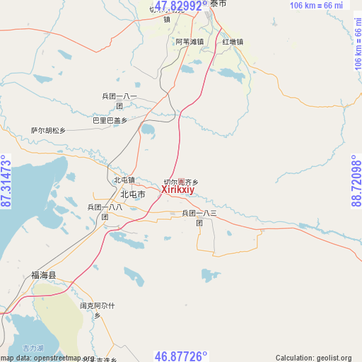
Xirikxiy GPS coordinates[2]
47° 21' 20.664" North, 88° 1' 4.26" East
| Map corner | latitude | longitude |
|---|---|---|
| Upper-left | 47.82992°, | 87.31473° |
| Center: | 47.35574°, | 88.01785° |
| Lower-right: | 46.87726°, | 88.72098° |
| Map W x H: | 105.9×105.9 km | = 65.8×65.8mi |
| max Lat: | 53.31946° ⇑2.3% North |
| Xirikxiy: | 47.35574° |
| min Lat: | ⇓97.7% South 18.22056° |
| min Long | Xirikxiy | max Long |
| 75.07348° | 88.01785° | 134.28917° |
| W 2.1%⇐ | ⇒97.9% E |
Elevation
Elevation of Xirikxiy is 530 m = 1739 ft, and this is 45.2 m = 148 ft above average elevation for this country.
| Max E: |
5622 m = 18445 ft | 24.6% |
| Xirikxiy | 530 m 1739 ft | |
| Avg. | 484.8 m = 1591 ft | |
Min E: |
-3 m = -10 ft | 75.4% |
See also: China elevation on elevation.city.
Geographical zone
Xirikxiy is located in North temperate zone (between Tropic of Cancer and the Arctic Circle). Distance of this North polar circle is 2135.7 km =1327.1 mi to North.| Distance of | km | miles | from Xirikxiy |
|---|---|---|---|
| North Pole | 4741.6 | 2946.3 | to North |
| Arctic Circle | 2135.7 | 1327.1 | to North |
| Tropic Cancer | 2659.5 | 1652.5 | to South |
| Equator | 5265.5 | 3271.8 | to South |


Nearby cities:
15 places around Xirikxiy: (largest is in red/bold)
• Alakak
58.2 km =36.2 mi,  317°
317°
• Altay
55.5 km =34.5 mi,  8°
8°
• Awiytan
41.1 km =25.5 mi,  3°
3°
• A’erda
45.7 km =28.4 mi,  237°
237°
• Balbagay
27.5 km =17.1 mi,  311°
311°
• Beitun
14.9 km =9.3 mi,  268°
268°
• Fuhai
48.5 km =30.1 mi, 235°
• Handegate
53.4 km =33.2 mi,  30°
30°
• Hongdun
43.6 km =27.1 mi,  20°
20°
• Jetaral
51.9 km =32.2 mi, 236°
• Kalaxilike
59 km =36.7 mi, 314°
• Kokagax
45.1 km =28 mi,  213°
213°
• Qiganjidie
59.2 km =36.8 mi,  202°
202°
• Sa’erhusong
39 km =24.2 mi,  293°
293°
• Xemirxek
49.1 km =30.5 mi,  355°
355°
Sources, notices
• [Note1] Compared only with cities in China existing in our database
• [Src1] Map data: © OpenStreetMap contributors (CC-BY-SA)
• [Src2] Other city data from geonames.org with taken over terms of usage.
• [Src3] Geographical zone / Annual Mean Temperature by Robert A. Rohde @ Wikipedia
