Hongdun geodata
Hongdun (Xinjiang) is a seat of a fourth-order administrative division; located in China in Asia/Urumqi (GMT+6) time zone. In our database, there are 1268 cities with bigger population. Compared to other cities in China, 98.2% of cities are located further ↓South; 97.8% of cities are located further →East and 80.5% of cities have lower elevation than Hongdun. Note1


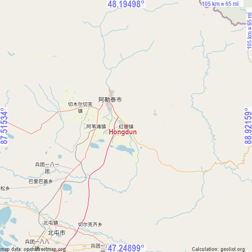
Hongdun GPS coordinates[2]
47° 43' 26.868" North, 88° 13' 6.456" East
| Map corner | latitude | longitude |
|---|---|---|
| Upper-left | 48.19498°, | 87.51534° |
| Center: | 47.72413°, | 88.21846° |
| Lower-right: | 47.24899°, | 88.92159° |
| Map W x H: | 105.2×105.2 km | = 65.4×65.4mi |
| max Lat: | 53.31946° ⇑1.8% North |
| Hongdun: | 47.72413° |
| min Lat: | ⇓98.2% South 18.22056° |
| min Long | Hongdun | max Long |
| 75.07348° | 88.21846° | 134.28917° |
| W 2.2%⇐ | ⇒97.8% E |
Elevation
Elevation of Hongdun is 720 m = 2362 ft, and this is 235.2 m = 772 ft above average elevation for this country.
| Max E: |
5622 m = 18445 ft | 19.5% |
| Hongdun | 720 m 2362 ft | |
| Avg. | 484.8 m = 1591 ft | |
Min E: |
-3 m = -10 ft | 80.5% |
See also: China elevation on elevation.city.
Geographical zone
Hongdun is located in North temperate zone (between Tropic of Cancer and the Arctic Circle). Distance of this North polar circle is 2094.7 km =1301.6 mi to North.| Distance of | km | miles | from Hongdun |
|---|---|---|---|
| North Pole | 4700.6 | 2920.8 | to North |
| Arctic Circle | 2094.7 | 1301.6 | to North |
| Tropic Cancer | 2700.5 | 1678 | to South |
| Equator | 5306.4 | 3297.2 | to South |


Nearby cities:
15 places around Hongdun: (largest is in red/bold)
• Alakak
53.9 km =33.5 mi,  272°
272°
• Altay
15.2 km =9.4 mi,  335°
335°
• Awiytan
12.5 km =7.8 mi, 270°
• A’erda
84.7 km =52.6 mi,  219°
219°
• Balbagay
42.4 km =26.3 mi,  237°
237°
• Beitun
51 km =31.7 mi, 215°
• Fuhai
87.7 km =54.5 mi, 218°
• Handegate
13.1 km =8.1 mi,  67°
67°
• Kalaxilike
56.8 km =35.3 mi, 270°
• Kokagax
88.2 km =54.8 mi,  206°
206°
• Kostik
66.7 km =41.4 mi,  275°
275°
• Lasite
20.2 km =12.6 mi, 336°
• Sa’erhusong
56.8 km =35.3 mi, 243°
• Xemirxek
20.5 km =12.7 mi,  293°
293°
• Xirikxiy
43.6 km =27.1 mi,  200°
200°
Sources, notices
• [Note1] Compared only with cities in China existing in our database
• [Src1] Map data: © OpenStreetMap contributors (CC-BY-SA)
• [Src2] Other city data from geonames.org with taken over terms of usage.
• [Src3] Geographical zone / Annual Mean Temperature by Robert A. Rohde @ Wikipedia
