Xitou geodata
Xitou (Anhui) is a seat of a fourth-order administrative division; located in China in Asia/Shanghai (GMT+8) time zone. In our database, there are 1268 cities with bigger population. Compared to other cities in China, 53.9% of cities are located further ↑North; 73% of cities are located further ←West and 51.2% of cities have higher elevation than Xitou. Note1


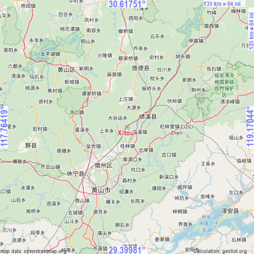
Xitou GPS coordinates[2]
30° 0' 37.908" North, 118° 28' 2.316" East
| Map corner | latitude | longitude |
|---|---|---|
| Upper-left | 30.61751°, | 117.76419° |
| Center: | 30.01053°, | 118.46731° |
| Lower-right: | 29.39981°, | 119.17044° |
| Map W x H: | 135.4×135.4 km | = 84.1×84.1mi |
| max Lat: | 53.31946° ⇑53.9% North |
| Xitou: | 30.01053° |
| min Lat: | ⇓46.1% South 18.22056° |
| min Long | Xitou | max Long |
| 75.07348° | 118.46731° | 134.28917° |
| W 73%⇐ | ⇒27% E |
Elevation
Elevation of Xitou is 155 m = 509 ft, and this is 329.8 m = 1082 ft below average elevation for this country.
| Max E: |
5622 m = 18445 ft | 51.2% |
| Avg. | 484.8 m = 1591 ft | |
| Xitou | 155 m = 509 ft | |
Min E: |
-3 m = -10 ft | 48.8% |
See also: China elevation on elevation.city.
Geographical zone
Xitou is located in North temperate zone (between Tropic of Cancer and the Arctic Circle). Distance of this Northern Tropic circle is 730.9 km =454.2 mi to South.| Distance of | km | miles | from Xitou |
|---|---|---|---|
| North Pole | 6670.2 | 4144.7 | to North |
| Arctic Circle | 4064.3 | 2525.4 | to North |
| Tropic Cancer | 730.9 | 454.2 | to South |
| Equator | 3336.9 | 2073.5 | to South |


Nearby cities:
15 places around Xitou: (largest is in red/bold)
• Bei’an
15.3 km =9.5 mi,  137°
137°
• Chang’an
16.5 km =10.3 mi,  17°
17°
• Chengcunjiang
15.1 km =9.4 mi,  153°
153°
• Daguyun
7.1 km =4.4 mi,  322°
322°
• Fu’e
14.6 km =9.1 mi,  218°
218°
• Guilin
9.8 km =6.1 mi,  179°
179°
• Huangcun
6.1 km =3.8 mi,  274°
274°
• Huayang
13.6 km =8.5 mi,  60°
60°
• Huicheng
16 km =9.9 mi,  191°
191°
• Linxi
6.9 km =4.3 mi,  109°
109°
• Nanyuankou
17.5 km =10.9 mi,  172°
172°
• Shangfeng
11.1 km =6.9 mi,  261°
261°
• Shangzhuang
13.1 km =8.1 mi,  345°
345°
• Xucun
14.6 km =9.1 mi, 264°
• Yingzhou
18 km =11.2 mi,  71°
71°
Sources, notices
• [Note1] Compared only with cities in China existing in our database
• [Src1] Map data: © OpenStreetMap contributors (CC-BY-SA)
• [Src2] Other city data from geonames.org with taken over terms of usage.
• [Src3] Geographical zone / Annual Mean Temperature by Robert A. Rohde @ Wikipedia
