Linxi geodata
Linxi (Anhui) is a seat of a fourth-order administrative division; located in China in Asia/Shanghai (GMT+8) time zone. In our database, there are 1268 cities with bigger population. Compared to other cities in China, 54.1% of cities are located further ↑North; 73.5% of cities are located further ←West and 53.5% of cities have higher elevation than Linxi. Note1


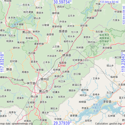
Linxi GPS coordinates[2]
29° 59' 24.828" North, 118° 32' 7.08" East
| Map corner | latitude | longitude |
|---|---|---|
| Upper-left | 30.59734°, | 117.83218° |
| Center: | 29.99023°, | 118.5353° |
| Lower-right: | 29.37939°, | 119.23843° |
| Map W x H: | 135.4×135.4 km | = 84.1×84.1mi |
| max Lat: | 53.31946° ⇑54.1% North |
| Linxi: | 29.99023° |
| min Lat: | ⇓45.9% South 18.22056° |
| min Long | Linxi | max Long |
| 75.07348° | 118.5353° | 134.28917° |
| W 73.5%⇐ | ⇒26.5% E |
Elevation
Elevation of Linxi is 140 m = 459 ft, and this is 344.8 m = 1131 ft below average elevation for this country.
| Max E: |
5622 m = 18445 ft | 53.5% |
| Avg. | 484.8 m = 1591 ft | |
| Linxi | 140 m = 459 ft | |
Min E: |
-3 m = -10 ft | 46.5% |
See also: China elevation on elevation.city.
Geographical zone
Linxi is located in North temperate zone (between Tropic of Cancer and the Arctic Circle). Distance of this Northern Tropic circle is 728.7 km =452.8 mi to South.| Distance of | km | miles | from Linxi |
|---|---|---|---|
| North Pole | 6672.5 | 4146.1 | to North |
| Arctic Circle | 4066.6 | 2526.9 | to North |
| Tropic Cancer | 728.7 | 452.8 | to South |
| Equator | 3334.6 | 2072 | to South |


Nearby cities:
15 places around Linxi: (largest is in red/bold)
• Bei’an
9.7 km =6 mi,  156°
156°
• Changxi
13.6 km =8.5 mi,  129°
129°
• Chengcunjiang
11.2 km =7 mi,  178°
178°
• Daguyun
13.4 km =8.3 mi,  305°
305°
• Guilin
10 km =6.2 mi,  220°
220°
• Huangcun
13 km =8.1 mi,  282°
282°
• Huayang
10.4 km =6.5 mi,  30°
30°
• Huicheng
16.6 km =10.3 mi, 216°
• Nanyuankou
15.8 km =9.8 mi,  196°
196°
• Shangfeng
17.6 km =10.9 mi,  271°
271°
• Shendu
15.5 km =9.6 mi,  151°
151°
• Sucun
16.2 km =10.1 mi,  93°
93°
• Xiakeng
12.7 km =7.9 mi,  105°
105°
• Xitou
6.9 km =4.3 mi,  289°
289°
• Yingzhou
13.2 km =8.2 mi,  52°
52°
Sources, notices
• [Note1] Compared only with cities in China existing in our database
• [Src1] Map data: © OpenStreetMap contributors (CC-BY-SA)
• [Src2] Other city data from geonames.org with taken over terms of usage.
• [Src3] Geographical zone / Annual Mean Temperature by Robert A. Rohde @ Wikipedia
