Yunle geodata
Yunle (Anhui) is a seat of a fourth-order administrative division; located in China in Asia/Shanghai (GMT+8) time zone. In our database, there are 1268 cities with bigger population. Compared to other cities in China, 50% of cities are located further ↓South; 74% of cities are located further ←West and 60.6% of cities have lower elevation than Yunle. Note1


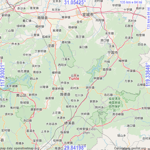
Yunle GPS coordinates[2]
30° 27' 0" North, 118° 37' 59.988" East
| Map corner | latitude | longitude |
|---|---|---|
| Upper-left | 31.05425°, | 117.93021° |
| Center: | 30.45°, | 118.63333° |
| Lower-right: | 29.84198°, | 119.33646° |
| Map W x H: | 134.8×134.8 km | = 83.8×83.8mi |
| max Lat: | 53.31946° ⇑50% North |
| Yunle: | 30.45° |
| min Lat: | ⇓50% South 18.22056° |
| min Long | Yunle | max Long |
| 75.07348° | 118.63333° | 134.28917° |
| W 74%⇐ | ⇒26% E |
Elevation
Elevation of Yunle is 267 m = 876 ft, and this is 217.8 m = 715 ft below average elevation for this country.
| Max E: |
5622 m = 18445 ft | 39.4% |
| Avg. | 484.8 m = 1591 ft | |
| Yunle | 267 m = 876 ft | |
Min E: |
-3 m = -10 ft | 60.6% |
See also: China elevation on elevation.city.
Geographical zone
Yunle is located in North temperate zone (between Tropic of Cancer and the Arctic Circle). Distance of this Northern Tropic circle is 779.8 km =484.5 mi to South.| Distance of | km | miles | from Yunle |
|---|---|---|---|
| North Pole | 6621.3 | 4114.3 | to North |
| Arctic Circle | 4015.5 | 2495.1 | to North |
| Tropic Cancer | 779.8 | 484.5 | to South |
| Equator | 3385.7 | 2103.8 | to South |


Nearby cities:
15 places around Yunle: (largest is in red/bold)
• Caijiaqiao
19.7 km =12.2 mi,  232°
232°
• Fangtang
9.7 km =6 mi,  70°
70°
• Huatan
16.3 km =10.1 mi,  214°
214°
• Hule
17.2 km =10.7 mi,  128°
128°
• Jialu
20.6 km =12.8 mi,  97°
97°
• Jingqiao
15.7 km =9.8 mi,  196°
196°
• Jingyang
19.6 km =12.2 mi, 206°
• Langqiao
17.6 km =10.9 mi,  280°
280°
• Qiaoting
10.7 km =6.6 mi, 230°
• Sanxi
21.3 km =13.2 mi,  247°
247°
• Shichuan
17.6 km =10.9 mi,  168°
168°
• Suhong
16.6 km =10.3 mi,  329°
329°
• Tingxi
17.5 km =10.9 mi,  352°
352°
• Xiyang
14.7 km =9.1 mi,  308°
308°
• Yucun
11.2 km =7 mi,  180°
180°
Sources, notices
• [Note1] Compared only with cities in China existing in our database
• [Src1] Map data: © OpenStreetMap contributors (CC-BY-SA)
• [Src2] Other city data from geonames.org with taken over terms of usage.
• [Src3] Geographical zone / Annual Mean Temperature by Robert A. Rohde @ Wikipedia
