Longshan geodata
Longshan (Anhui) is a seat of a fourth-order administrative division; located in China in Asia/Shanghai (GMT+8) time zone. In our database, there are 1268 cities with bigger population. Compared to other cities in China, 64% of cities are located further ↓South; 73.6% of cities are located further ←West and 71.9% of cities have higher elevation than Longshan. Note1


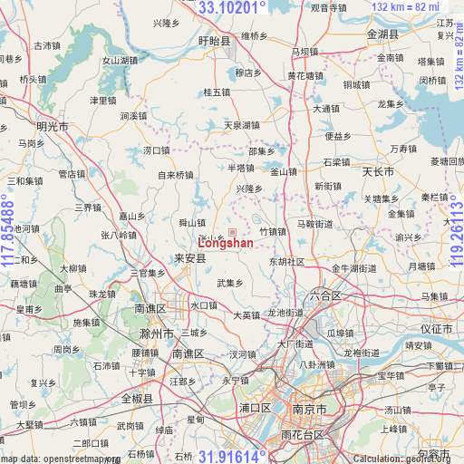
Longshan GPS coordinates[2]
32° 30' 39.708" North, 118° 33' 28.8" East
| Map corner | latitude | longitude |
|---|---|---|
| Upper-left | 33.10201°, | 117.85488° |
| Center: | 32.51103°, | 118.558° |
| Lower-right: | 31.91614°, | 119.26113° |
| Map W x H: | 131.9×131.9 km | = 82×82mi |
| max Lat: | 53.31946° ⇑36% North |
| Longshan: | 32.51103° |
| min Lat: | ⇓64% South 18.22056° |
| min Long | Longshan | max Long |
| 75.07348° | 118.558° | 134.28917° |
| W 73.6%⇐ | ⇒26.4% E |
Elevation
Elevation of Longshan is 45 m = 148 ft, and this is 439.8 m = 1443 ft below average elevation for this country.
| Max E: |
5622 m = 18445 ft | 71.9% |
| Avg. | 484.8 m = 1591 ft | |
| Longshan | 45 m = 148 ft | |
Min E: |
-3 m = -10 ft | 28.1% |
See also: China elevation on elevation.city.
Geographical zone
Longshan is located in North temperate zone (between Tropic of Cancer and the Arctic Circle). Distance of this Northern Tropic circle is 1009 km =627 mi to South.| Distance of | km | miles | from Longshan |
|---|---|---|---|
| North Pole | 6392.2 | 3971.9 | to North |
| Arctic Circle | 3786.3 | 2352.7 | to North |
| Tropic Cancer | 1009 | 627 | to South |
| Equator | 3614.9 | 2246.2 | to South |


Nearby cities:
15 places around Longshan: (largest is in red/bold)
• Chajian
27.1 km =16.8 mi,  47°
47°
• Chengqiao
20.8 km =12.9 mi,  131°
131°
• Chuzhou
32.2 km =20 mi,  229°
229°
• Daying
23.5 km =14.6 mi,  170°
170°
• Dushan
14.2 km =8.8 mi,  143°
143°
• Leiguan
19.1 km =11.9 mi,  163°
163°
• Maji
23.5 km =14.6 mi,  84°
84°
• Ma’an
27.6 km =17.1 mi,  114°
114°
• Shiguan
5.9 km =3.7 mi, 165°
• Wangdian
31.3 km =19.4 mi,  4°
4°
• Xinji
26.9 km =16.7 mi,  146°
146°
• Xinjie
30.1 km =18.7 mi,  63°
63°
• Xin’an
16.2 km =10.1 mi,  239°
239°
• Xiongzhou
33.1 km =20.6 mi,  124°
124°
• Zhuzhen
11.2 km =7 mi,  87°
87°
Sources, notices
• [Note1] Compared only with cities in China existing in our database
• [Src1] Map data: © OpenStreetMap contributors (CC-BY-SA)
• [Src2] Other city data from geonames.org with taken over terms of usage.
• [Src3] Geographical zone / Annual Mean Temperature by Robert A. Rohde @ Wikipedia
