Chuzhou geodata
Chuzhou (Anhui) is a populated place; located in China in Asia/Shanghai (GMT+8) time zone. With population of 280,582 people, there are 184 cities with bigger population in this country. Compared to other cities in China, 63.1% of cities are located further ↓South; 71.9% of cities are located further ←West and 81.2% of cities have higher elevation than Chuzhou. Note1


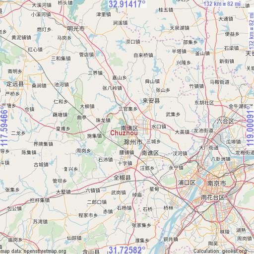
Chuzhou GPS coordinates[2]
32° 19' 18.984" North, 118° 17' 52.008" East
| Map corner | latitude | longitude |
|---|---|---|
| Upper-left | 32.91417°, | 117.59466° |
| Center: | 32.32194°, | 118.29778° |
| Lower-right: | 31.72582°, | 119.00091° |
| Map W x H: | 132.1×132.1 km | = 82.1×82.1mi |
| max Lat: | 53.31946° ⇑36.9% North |
| Chuzhou: | 32.32194° |
| min Lat: | ⇓63.1% South 18.22056° |
| min Long | Chuzhou | max Long |
| 75.07348° | 118.29778° | 134.28917° |
| W 71.9%⇐ | ⇒28.1% E |
Elevation
Elevation of Chuzhou is 24 m = 79 ft, and this is 460.8 m = 1512 ft below average elevation for this country.
| Max E: |
5622 m = 18445 ft | 81.2% |
| Avg. | 484.8 m = 1591 ft | |
| Chuzhou | 24 m = 79 ft | |
Min E: |
-3 m = -10 ft | 18.8% |
See also: Chuzhou elevation on elevation.city.
Geographical zone
Chuzhou is located in North temperate zone (between Tropic of Cancer and the Arctic Circle). Distance of this Northern Tropic circle is 987.9 km =613.9 mi to South.| Distance of | km | miles | from Chuzhou |
|---|---|---|---|
| North Pole | 6413.2 | 3985 | to North |
| Arctic Circle | 3807.3 | 2365.7 | to North |
| Tropic Cancer | 987.9 | 613.9 | to South |
| Equator | 3593.9 | 2233.1 | to South |


Nearby cities:
15 places around Chuzhou: (largest is in red/bold)
• Chahe
30.1 km =18.7 mi,  115°
115°
• Chengqiao
40.6 km =25.2 mi,  79°
79°
• Daying
28.6 km =17.8 mi,  94°
94°
• Dushan
34.2 km =21.3 mi,  73°
73°
• Leiguan
30 km =18.6 mi, 84°
• Longshan
32.2 km =20 mi,  49°
49°
• Pancheng
40.5 km =25.2 mi,  107°
107°
• Shiguan
30.1 km =18.7 mi,  59°
59°
• Shiyang
41.4 km =25.7 mi,  182°
182°
• Shuining
31.9 km =19.8 mi,  128°
128°
• Tangquan
32.2 km =20 mi,  142°
142°
• Xingdian
34 km =21.1 mi,  157°
157°
• Xinji
39.2 km =24.4 mi, 92°
• Xin’an
16.6 km =10.3 mi,  38°
38°
• Yongning
32.7 km =20.3 mi, 129°
Sources, notices
• [Note1] Compared only with cities in China existing in our database
• [Src1] Map data: © OpenStreetMap contributors (CC-BY-SA)
• [Src2] Other city data from geonames.org with taken over terms of usage.
• [Src3] Geographical zone / Annual Mean Temperature by Robert A. Rohde @ Wikipedia
