Toro geodata
Toro (Valle del Cauca) is a seat of a second-order administrative division; located in Colombia in America/Bogota (GMT-5) time zone. With population of 13,764 people, there are 233 cities with bigger population in this country. Compared to other cities in Colombia, 69.6% of cities are located further ↑North; 81.5% of cities are located further →East and 53.9% of cities have higher elevation than Toro. Note1


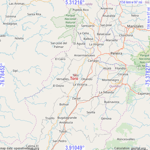
Toro GPS coordinates[2]
4° 36' 42.012" North, 76° 4' 53.004" West
| Map corner | latitude | longitude |
|---|---|---|
| Upper-left | 5.31216°, | -76.78452° |
| Center: | 4.61167°, | -76.08139° |
| Lower-right: | 3.91049°, | -75.37827° |
| Map W x H: | 155.9×155.9 km | = 96.9×96.9mi |
| max Lat: | 13.38166° ⇑69.6% North |
| Toro: | 4.61167° |
| min Lat: | ⇓30.4% South -4.21528° |
| min Long | Toro | max Long |
| -81.70636° | -76.08139° | -67.06996° |
| W 18.5%⇐ | ⇒81.5% E |
Elevation
Elevation of Toro is 992 m = 3255 ft, and this is 157.3 m = 516 ft below average elevation for this country.
| Max E: |
3342 m = 10965 ft | 53.9% |
| Avg. | 1149.3 m = 3771 ft | |
| Toro | 992 m = 3255 ft | |
Min E: |
1 m = 3 ft | 46.1% |
See also: Colombia elevation on elevation.city.
Geographical zone
Toro is located in North Torrid zone (between Equator and Tropic of Cancer). Distance of Equator is 512.8 km =318.6 mi to South.| Distance of | km | miles | from Toro |
|---|---|---|---|
| North Pole | 9494.3 | 5899.5 | to North |
| Arctic Circle | 6888.4 | 4280.3 | to North |
| Tropic Cancer | 2093.1 | 1300.6 | to North |
| Equator | 512.8 | 318.6 | to South |


Nearby cities:
15 places around Toro: (largest is in red/bold)
• Alcalá
33.9 km =21.1 mi,  78°
78°
• Ansermanuevo
22.7 km =14.1 mi,  24°
24°
• Argelia
13.1 km =8.1 mi,  341°
341°
• Bolívar
32.4 km =20.1 mi,  200°
200°
• Cartago
24 km =14.9 mi,  51°
51°
• El Cairo
22.8 km =14.2 mi,  317°
317°
• El Dovio
20.7 km =12.9 mi,  236°
236°
• El Águila
33.9 km =21.1 mi,  7°
7°
• La Unión
9.1 km =5.7 mi, 195°
• La Victoria
10.7 km =6.6 mi,  154°
154°
• Obando
12.6 km =7.8 mi,  108°
108°
• Quimbaya
35.3 km =21.9 mi,  87°
87°
• Roldanillo
23.6 km =14.7 mi, 200°
• Versalles
13.6 km =8.5 mi,  252°
252°
• Zarzal
24.2 km =15 mi,  177°
177°
Sources, notices
• [Note1] Compared only with cities in Colombia existing in our database
• [Src1] Map data: © OpenStreetMap contributors (CC-BY-SA)
• [Src2] Other city data from geonames.org with taken over terms of usage.
• [Src3] Geographical zone / Annual Mean Temperature by Robert A. Rohde @ Wikipedia
