Obando geodata
Obando (Valle del Cauca) is a seat of a second-order administrative division; located in Colombia in America/Bogota (GMT-5) time zone. With population of 7,298 people, there are 395 cities with bigger population in this country. Compared to other cities in Colombia, 70% of cities are located further ↑North; 79.5% of cities are located further →East and 57% of cities have higher elevation than Obando. Note1


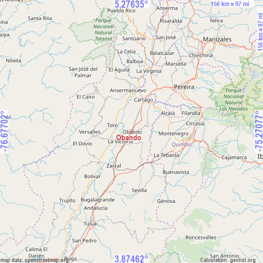
Obando GPS coordinates[2]
4° 34' 32.988" North, 75° 58' 26.004" West
| Map corner | latitude | longitude |
|---|---|---|
| Upper-left | 5.27635°, | -76.67702° |
| Center: | 4.57583°, | -75.97389° |
| Lower-right: | 3.87462°, | -75.27077° |
| Map W x H: | 155.9×155.9 km | = 96.9×96.9mi |
| max Lat: | 13.38166° ⇑70% North |
| Obando: | 4.57583° |
| min Lat: | ⇓30% South -4.21528° |
| min Long | Obando | max Long |
| -81.70636° | -75.97389° | -67.06996° |
| W 20.5%⇐ | ⇒79.5% E |
Elevation
Elevation of Obando is 932 m = 3058 ft, and this is 217.3 m = 713 ft below average elevation for this country.
| Max E: |
3342 m = 10965 ft | 57% |
| Avg. | 1149.3 m = 3771 ft | |
| Obando | 932 m = 3058 ft | |
Min E: |
1 m = 3 ft | 43% |
See also: Colombia elevation on elevation.city.
Geographical zone
Obando is located in North Torrid zone (between Equator and Tropic of Cancer). Distance of Equator is 508.8 km =316.2 mi to South.| Distance of | km | miles | from Obando |
|---|---|---|---|
| North Pole | 9498.3 | 5902 | to North |
| Arctic Circle | 6892.4 | 4282.7 | to North |
| Tropic Cancer | 2097.1 | 1303.1 | to North |
| Equator | 508.8 | 316.2 | to South |


Nearby cities:
15 places around Obando: (largest is in red/bold)
• Alcalá
23.9 km =14.9 mi,  62°
62°
• Ansermanuevo
24.7 km =15.3 mi,  354°
354°
• Argelia
23 km =14.3 mi,  315°
315°
• Cartago
20.2 km =12.6 mi,  19°
19°
• El Dovio
30 km =18.6 mi,  255°
255°
• La Tebaida
24.8 km =15.4 mi,  123°
123°
• La Unión
15.1 km =9.4 mi,  251°
251°
• La Victoria
9.2 km =5.7 mi,  231°
231°
• Montenegro
24.7 km =15.3 mi,  92°
92°
• Quimbaya
24 km =14.9 mi,  77°
77°
• Roldanillo
27 km =16.8 mi, 227°
• Toro
12.6 km =7.8 mi,  288°
288°
• Ulloa
29.6 km =18.4 mi, 61°
• Versalles
24.9 km =15.5 mi,  269°
269°
• Zarzal
22.9 km =14.2 mi,  208°
208°
Sources, notices
• [Note1] Compared only with cities in Colombia existing in our database
• [Src1] Map data: © OpenStreetMap contributors (CC-BY-SA)
• [Src2] Other city data from geonames.org with taken over terms of usage.
• [Src3] Geographical zone / Annual Mean Temperature by Robert A. Rohde @ Wikipedia
