Génova geodata
Génova (Quindío) is a populated place; located in Colombia in America/Bogota (GMT-5) time zone. With population of 7,140 people, there are 401 cities with bigger population in this country. Compared to other cities in Colombia, 74.3% of cities are located further ↑North; 74.3% of cities are located further →East and 52.5% of cities have lower elevation than Génova. Note1


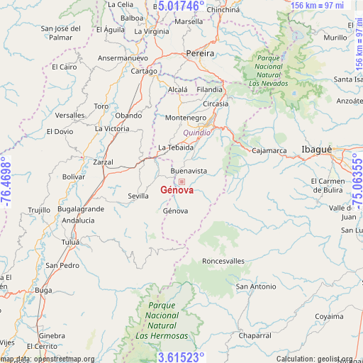
Génova GPS coordinates[2]
4° 19' 0.012" North, 75° 46' 0.012" West
| Map corner | latitude | longitude |
|---|---|---|
| Upper-left | 5.01746°, | -76.4698° |
| Center: | 4.31667°, | -75.76667° |
| Lower-right: | 3.61523°, | -75.06355° |
| Map W x H: | 155.9×155.9 km | = 96.9×96.9mi |
| max Lat: | 13.38166° ⇑74.3% North |
| Génova: | 4.31667° |
| min Lat: | ⇓25.7% South -4.21528° |
| min Long | Génova | max Long |
| -81.70636° | -75.76667° | -67.06996° |
| W 25.7%⇐ | ⇒74.3% E |
Elevation
Elevation of Génova is 1228 m = 4029 ft, and this is 78.7 m = 258 ft above average elevation for this country.
| Max E: |
3342 m = 10965 ft | 47.5% |
| Génova | 1228 m 4029 ft | |
| Avg. | 1149.3 m = 3771 ft | |
Min E: |
1 m = 3 ft | 52.5% |
See also: Colombia elevation on elevation.city.
Geographical zone
Génova is located in North Torrid zone (between Equator and Tropic of Cancer). Distance of Equator is 480 km =298.3 mi to South.| Distance of | km | miles | from Génova |
|---|---|---|---|
| North Pole | 9527.1 | 5919.9 | to North |
| Arctic Circle | 6921.2 | 4300.6 | to North |
| Tropic Cancer | 2126 | 1321 | to North |
| Equator | 480 | 298.3 | to South |


Nearby cities:
15 places around Génova: (largest is in red/bold)
• Anaime
36.7 km =22.8 mi,  76°
76°
• Armenia
25.9 km =16.1 mi,  21°
21°
• Buenavista
5.7 km =3.5 mi,  32°
32°
• Caicedonia
6.9 km =4.3 mi,  284°
284°
• Calarcá
27.5 km =17.1 mi, 30°
• Circasia
36.6 km =22.7 mi, 23°
• Córdoba
12.1 km =7.5 mi,  46°
46°
• Génova
12.3 km =7.6 mi,  191°
191°
• La Tebaida
15.3 km =9.5 mi,  351°
351°
• Montenegro
27.8 km =17.3 mi,  3°
3°
• Obando
36.9 km =22.9 mi,  321°
321°
• Pijao
7.1 km =4.4 mi,  74°
74°
• Quimbaya
34.1 km =21.2 mi, 0°
• Sevilla
19.1 km =11.9 mi,  252°
252°
• Zarzal
34.9 km =21.7 mi, 284°
Sources, notices
• [Note1] Compared only with cities in Colombia existing in our database
• [Src1] Map data: © OpenStreetMap contributors (CC-BY-SA)
• [Src2] Other city data from geonames.org with taken over terms of usage.
• [Src3] Geographical zone / Annual Mean Temperature by Robert A. Rohde @ Wikipedia
