Puerto Guzmán geodata
Puerto Guzmán (Putumayo) is a seat of a second-order administrative division; located in Colombia in America/Bogota (GMT-5) time zone. In our database, there are 1053 cities with bigger population. Compared to other cities in Colombia, 98% of cities are located further ↑North; 85.8% of cities are located further →East and 71% of cities have higher elevation than Puerto Guzmán. Note1


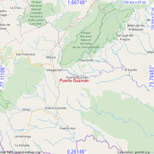
Puerto Guzmán GPS coordinates[2]
0° 57' 52.344" North, 76° 24' 28.62" West
| Map corner | latitude | longitude |
|---|---|---|
| Upper-left | 1.66748°, | -77.11108° |
| Center: | 0.96454°, | -76.40795° |
| Lower-right: | 0.26146°, | -75.70483° |
| Map W x H: | 156.3×156.3 km | = 97.1×97.1mi |
| max Lat: | 13.38166° ⇑98% North |
| Puerto Guzmán: | 0.96454° |
| min Lat: | ⇓2% South -4.21528° |
| min Long | Puerto Guzmán | max Long |
| -81.70636° | -76.40795° | -67.06996° |
| W 14.2%⇐ | ⇒85.8% E |
Elevation
Elevation of Puerto Guzmán is 277 m = 909 ft, and this is 872.3 m = 2862 ft below average elevation for this country.
| Max E: |
3342 m = 10965 ft | 71% |
| Avg. | 1149.3 m = 3771 ft | |
| Puerto Guzmán | 277 m = 909 ft | |
Min E: |
1 m = 3 ft | 29% |
See also: Colombia elevation on elevation.city.
Geographical zone
Puerto Guzmán is located in North Torrid zone (between Equator and Tropic of Cancer). Distance of Equator is 107.2 km =66.6 mi to South.| Distance of | km | miles | from Puerto Guzmán |
|---|---|---|---|
| North Pole | 9899.8 | 6151.4 | to North |
| Arctic Circle | 7293.9 | 4532.2 | to North |
| Tropic Cancer | 2498.7 | 1552.6 | to North |
| Equator | 107.2 | 66.6 | to South |


Nearby cities:
15 places around Puerto Guzmán: (largest is in red/bold)
• Albania
71.5 km =44.4 mi,  55°
55°
• Belén de los Andaquíes
77.6 km =48.2 mi,  49°
49°
• Colón
67.7 km =42.1 mi,  291°
291°
• Curillo
54.9 km =34.1 mi,  81°
81°
• Mocoa
34.3 km =21.3 mi,  307°
307°
• Orito
61.3 km =38.1 mi,  237°
237°
• Piamonte
19.8 km =12.3 mi,  29°
29°
• Puerto Asís
52 km =32.3 mi,  190°
190°
• Puerto Caicedo
38.1 km =23.7 mi,  214°
214°
• Puerto Guzmán
19.8 km =12.3 mi,  271°
271°
• San Francisco
57.4 km =35.7 mi, 294°
• San José del Fragua
63.2 km =39.3 mi, 49°
• Santiago
69.4 km =43.1 mi, 287°
• Sibundoy
63.1 km =39.2 mi, 294°
• Villagarzón
25.6 km =15.9 mi, 288°
Sources, notices
• [Note1] Compared only with cities in Colombia existing in our database
• [Src1] Map data: © OpenStreetMap contributors (CC-BY-SA)
• [Src2] Other city data from geonames.org with taken over terms of usage.
• [Src3] Geographical zone / Annual Mean Temperature by Robert A. Rohde @ Wikipedia
