Orito geodata
Orito (Putumayo) is a populated place; located in Colombia in America/Bogota (GMT-5) time zone. With population of 13,708 people, there are 234 cities with bigger population in this country. Compared to other cities in Colombia, 99.3% of cities are located further ↑North; 91.1% of cities are located further →East and 67.4% of cities have higher elevation than Orito. Note1


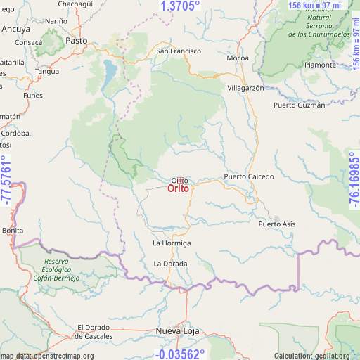
Orito GPS coordinates[2]
0° 40' 2.964" North, 76° 52' 22.692" West
| Map corner | latitude | longitude |
|---|---|---|
| Upper-left | 1.3705°, | -77.5761° |
| Center: | 0.66749°, | -76.87297° |
| Lower-right: | -0.03562°, | -76.16985° |
| Map W x H: | 156.3×156.3 km | = 97.1×97.1mi |
| max Lat: | 13.38166° ⇑99.3% North |
| Orito: | 0.66749° |
| min Lat: | ⇓0.7% South -4.21528° |
| min Long | Orito | max Long |
| -81.70636° | -76.87297° | -67.06996° |
| W 8.9%⇐ | ⇒91.1% E |
Elevation
Elevation of Orito is 349 m = 1145 ft, and this is 800.3 m = 2626 ft below average elevation for this country.
| Max E: |
3342 m = 10965 ft | 67.4% |
| Avg. | 1149.3 m = 3771 ft | |
| Orito | 349 m = 1145 ft | |
Min E: |
1 m = 3 ft | 32.6% |
See also: Colombia elevation on elevation.city.
Geographical zone
Orito is located in North Torrid zone (between Equator and Tropic of Cancer). Distance of Equator is 74.2 km =46.1 mi to South.| Distance of | km | miles | from Orito |
|---|---|---|---|
| North Pole | 9932.8 | 6172 | to North |
| Arctic Circle | 7327 | 4552.8 | to North |
| Tropic Cancer | 2531.7 | 1573.1 | to North |
| Equator | 74.2 | 46.1 | to South |


Nearby cities:
15 places around Orito: (largest is in red/bold)
• Colón
59.2 km =36.8 mi,  349°
349°
• Funes
74 km =46 mi,  300°
300°
• La Dorada
36.3 km =22.6 mi,  186°
186°
• La Hormiga
27.1 km =16.8 mi, 187°
• Mocoa
59.3 km =36.8 mi,  24°
24°
• Puerres
73.1 km =45.4 mi,  323°
323°
• Puerto Asís
45.7 km =28.4 mi,  113°
113°
• Puerto Caicedo
29.9 km =18.6 mi,  86°
86°
• Puerto Guzmán
46.4 km =28.8 mi,  43°
43°
• Puerto Guzmán
61.3 km =38.1 mi,  57°
57°
• San Francisco
56.6 km =35.2 mi,  359°
359°
• Santiago
55.4 km =34.4 mi,  344°
344°
• Sibundoy
59.8 km =37.2 mi, 354°
• Valle del Guamuez
24.5 km =15.2 mi, 192°
• Villagarzón
49.4 km =30.7 mi,  33°
33°
Sources, notices
• [Note1] Compared only with cities in Colombia existing in our database
• [Src1] Map data: © OpenStreetMap contributors (CC-BY-SA)
• [Src2] Other city data from geonames.org with taken over terms of usage.
• [Src3] Geographical zone / Annual Mean Temperature by Robert A. Rohde @ Wikipedia
