Tubará geodata
Tubará (Atlántico) is a populated place; located in Colombia in America/Bogota (GMT-5) time zone. With population of 8,180 people, there are 364 cities with bigger population in this country. Compared to other cities in Colombia, 98.4% of cities are located further ↓South; 53.7% of cities are located further →East and 72.1% of cities have higher elevation than Tubará. Note1


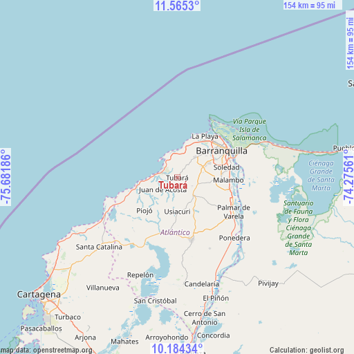
Tubará GPS coordinates[2]
10° 52' 32.232" North, 74° 58' 43.428" West
| Map corner | latitude | longitude |
|---|---|---|
| Upper-left | 11.5653°, | -75.68186° |
| Center: | 10.87562°, | -74.97873° |
| Lower-right: | 10.18434°, | -74.27561° |
| Map W x H: | 153.5×153.6 km | = 95.4×95.4mi |
| max Lat: | 13.38166° ⇑1.6% North |
| Tubará: | 10.87562° |
| min Lat: | ⇓98.4% South -4.21528° |
| min Long | Tubará | max Long |
| -81.70636° | -74.97873° | -67.06996° |
| W 46.3%⇐ | ⇒53.7% E |
Elevation
Elevation of Tubará is 252 m = 827 ft, and this is 897.3 m = 2944 ft below average elevation for this country.
| Max E: |
3342 m = 10965 ft | 72.1% |
| Avg. | 1149.3 m = 3771 ft | |
| Tubará | 252 m = 827 ft | |
Min E: |
1 m = 3 ft | 27.9% |
See also: Colombia elevation on elevation.city.
Geographical zone
Tubará is located in North Torrid zone (between Equator and Tropic of Cancer). Distance of Equator is 1209.3 km =751.4 mi to South.| Distance of | km | miles | from Tubará |
|---|---|---|---|
| North Pole | 8797.8 | 5466.7 | to North |
| Arctic Circle | 6191.9 | 3847.5 | to North |
| Tropic Cancer | 1396.7 | 867.9 | to North |
| Equator | 1209.3 | 751.4 | to South |


Nearby cities:
15 places around Tubará: (largest is in red/bold)
• Baranoa
11.3 km =7 mi,  143°
143°
• Barranquilla
23.9 km =14.9 mi,  64°
64°
• Galapa
10.4 km =6.5 mi,  76°
76°
• Juan de Acosta
7.9 km =4.9 mi,  229°
229°
• Malambo
22.4 km =13.9 mi,  94°
94°
• Palmar de Varela
28.7 km =17.8 mi,  121°
121°
• Piojó
20 km =12.4 mi,  224°
224°
• Polonuevo
17.5 km =10.9 mi,  128°
128°
• Puerto Colombia
12.7 km =7.9 mi,  11°
11°
• Sabanagrande
25.6 km =15.9 mi,  111°
111°
• Sabanalarga
27.9 km =17.3 mi,  167°
167°
• Santo Tomás
27.8 km =17.3 mi, 118°
• Sitionuevo
30.2 km =18.8 mi, 111°
• Soledad
23.9 km =14.9 mi, 78°
• Usiacurí
14.7 km =9.1 mi,  178°
178°
Sources, notices
• [Note1] Compared only with cities in Colombia existing in our database
• [Src1] Map data: © OpenStreetMap contributors (CC-BY-SA)
• [Src2] Other city data from geonames.org with taken over terms of usage.
• [Src3] Geographical zone / Annual Mean Temperature by Robert A. Rohde @ Wikipedia
