Piojó geodata
Piojó (Atlántico) is a seat of a second-order administrative division; located in Colombia in America/Bogota (GMT-5) time zone. With population of 3,388 people, there are 647 cities with bigger population in this country. Compared to other cities in Colombia, 97.5% of cities are located further ↓South; 56.5% of cities are located further →East and 69.3% of cities have higher elevation than Piojó. Note1


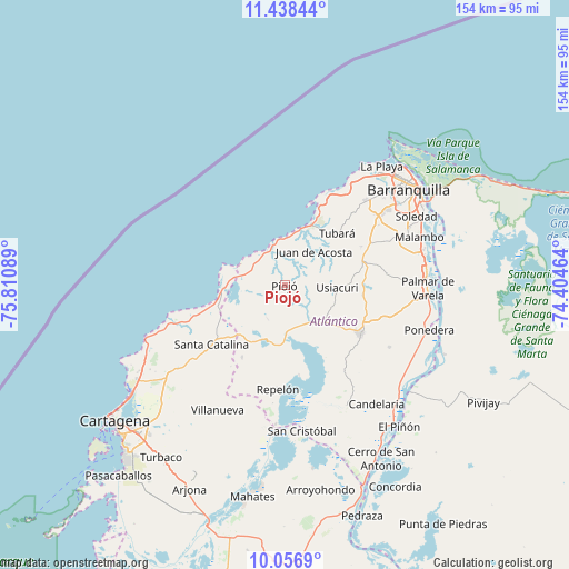
Piojó GPS coordinates[2]
10° 44' 54.456" North, 75° 6' 27.936" West
| Map corner | latitude | longitude |
|---|---|---|
| Upper-left | 11.43844°, | -75.81089° |
| Center: | 10.74846°, | -75.10776° |
| Lower-right: | 10.0569°, | -74.40464° |
| Map W x H: | 153.6×153.6 km | = 95.4×95.4mi |
| max Lat: | 13.38166° ⇑2.5% North |
| Piojó: | 10.74846° |
| min Lat: | ⇓97.5% South -4.21528° |
| min Long | Piojó | max Long |
| -81.70636° | -75.10776° | -67.06996° |
| W 43.5%⇐ | ⇒56.5% E |
Elevation
Elevation of Piojó is 307 m = 1007 ft, and this is 842.3 m = 2763 ft below average elevation for this country.
| Max E: |
3342 m = 10965 ft | 69.3% |
| Avg. | 1149.3 m = 3771 ft | |
| Piojó | 307 m = 1007 ft | |
Min E: |
1 m = 3 ft | 30.7% |
See also: Colombia elevation on elevation.city.
Geographical zone
Piojó is located in North Torrid zone (between Equator and Tropic of Cancer). Distance of Equator is 1195.1 km =742.6 mi to South.| Distance of | km | miles | from Piojó |
|---|---|---|---|
| North Pole | 8811.9 | 5475.5 | to North |
| Arctic Circle | 6206.1 | 3856.3 | to North |
| Tropic Cancer | 1410.8 | 876.6 | to North |
| Equator | 1195.1 | 742.6 | to South |


Nearby cities:
15 places around Piojó: (largest is in red/bold)
• Baranoa
21.5 km =13.4 mi,  76°
76°
• Clemencia
31.2 km =19.4 mi,  229°
229°
• Galapa
29.3 km =18.2 mi,  55°
55°
• Juan de Acosta
12.1 km =7.5 mi,  42°
42°
• Luruaco
15.4 km =9.6 mi,  198°
198°
• Manatí
37.4 km =23.2 mi,  154°
154°
• Polonuevo
28 km =17.4 mi, 83°
• Puerto Colombia
31.4 km =19.5 mi,  32°
32°
• Repelón
28.2 km =17.5 mi,  183°
183°
• Sabanagrande
38.2 km =23.7 mi, 82°
• Sabanalarga
24.1 km =15 mi,  122°
122°
• Santa Catalina
25.5 km =15.8 mi, 230°
• Tubará
20 km =12.4 mi, 44°
• Usiacurí
14.4 km =8.9 mi,  92°
92°
• Villanueva
38.4 km =23.9 mi,  208°
208°
Sources, notices
• [Note1] Compared only with cities in Colombia existing in our database
• [Src1] Map data: © OpenStreetMap contributors (CC-BY-SA)
• [Src2] Other city data from geonames.org with taken over terms of usage.
• [Src3] Geographical zone / Annual Mean Temperature by Robert A. Rohde @ Wikipedia
