Barranquilla geodata
Barranquilla (Atlántico) is a seat of a first-order administrative division; located in Colombia in America/Bogota (GMT-5) time zone. With population of 1,380,425 people, there are 3 cities with bigger population in this country. Compared to other cities in Colombia, 98.9% of cities are located further ↓South; 51.2% of cities are located further ←West and 91.5% of cities have higher elevation than Barranquilla. Note1


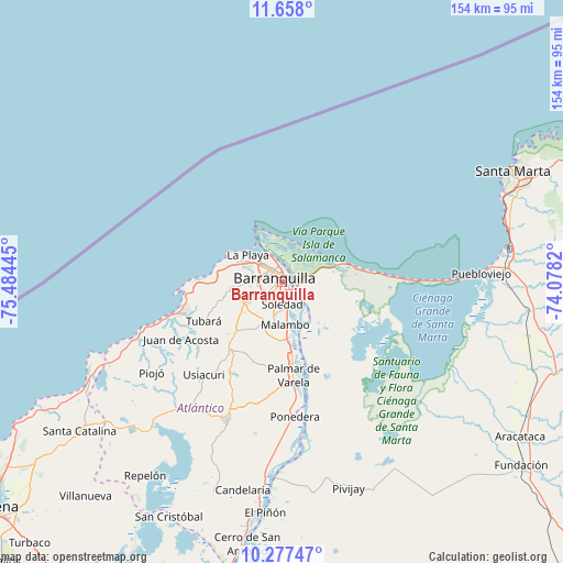
Barranquilla GPS coordinates[2]
10° 58' 6.744" North, 74° 46' 52.752" West
| Map corner | latitude | longitude |
|---|---|---|
| Upper-left | 11.658°, | -75.48445° |
| Center: | 10.96854°, | -74.78132° |
| Lower-right: | 10.27747°, | -74.0782° |
| Map W x H: | 153.5×153.5 km | = 95.4×95.4mi |
| max Lat: | 13.38166° ⇑1.1% North |
| Barranquilla: | 10.96854° |
| min Lat: | ⇓98.9% South -4.21528° |
| min Long | Barranquilla | max Long |
| -81.70636° | -74.78132° | -67.06996° |
| W 51.2%⇐ | ⇒48.8% E |
Elevation
Elevation of Barranquilla is 24 m = 79 ft, and this is 1125.3 m = 3692 ft below average elevation for this country.
| Max E: |
3342 m = 10965 ft | 91.5% |
| Avg. | 1149.3 m = 3771 ft | |
| Barranquilla | 24 m = 79 ft | |
Min E: |
1 m = 3 ft | 8.5% |
See also: Barranquilla elevation on elevation.city.
Geographical zone
Barranquilla is located in North Torrid zone (between Equator and Tropic of Cancer). Distance of Equator is 1219.6 km =757.8 mi to South.| Distance of | km | miles | from Barranquilla |
|---|---|---|---|
| North Pole | 8787.5 | 5460.3 | to North |
| Arctic Circle | 6181.6 | 3841.1 | to North |
| Tropic Cancer | 1386.3 | 861.4 | to North |
| Equator | 1219.6 | 757.8 | to South |


Nearby cities:
15 places around Barranquilla: (largest is in red/bold)
• Baranoa
24.4 km =15.2 mi,  217°
217°
• Galapa
13.9 km =8.6 mi,  235°
235°
• Juan de Acosta
31.6 km =19.6 mi, 240°
• Malambo
12.1 km =7.5 mi,  176°
176°
• Palmar de Varela
25.5 km =15.8 mi,  173°
173°
• Polonuevo
22.7 km =14.1 mi,  200°
200°
• Ponedera
36.3 km =22.6 mi, 175°
• Puerto Colombia
19 km =11.8 mi,  276°
276°
• Remolino
30.5 km =19 mi, 166°
• Sabanagrande
19.9 km =12.4 mi, 173°
• Santo Tomás
23.6 km =14.7 mi, 172°
• Sitionuevo
22.3 km =13.9 mi,  162°
162°
• Soledad
5.9 km =3.7 mi, 161°
• Tubará
23.9 km =14.9 mi, 244°
• Usiacurí
32.9 km =20.4 mi, 220°
In other languages:
- In Spanish: Barranquilla, Killa, Quilla, La Arenosa
- In Russian: Барранкилья
- In Chinese: 巴兰基亚
Sources, notices
• [Note1] Compared only with cities in Colombia existing in our database
• [Src1] Map data: © OpenStreetMap contributors (CC-BY-SA)
• [Src2] Other city data from geonames.org with taken over terms of usage.
• [Src3] Geographical zone / Annual Mean Temperature by Robert A. Rohde @ Wikipedia
