Tota geodata
Tota (Boyacá) is a seat of a second-order administrative division; located in Colombia in America/Bogota (GMT-5) time zone. With population of 774 people, there are 985 cities with bigger population in this country. Compared to other cities in Colombia, 51.1% of cities are located further ↓South; 86.7% of cities are located further ←West and 97.8% of cities have lower elevation than Tota. Note1


Tota GPS coordinates[2]
5° 33' 29.988" North, 72° 59' 15.252" West
| Map corner | latitude | longitude |
|---|---|---|
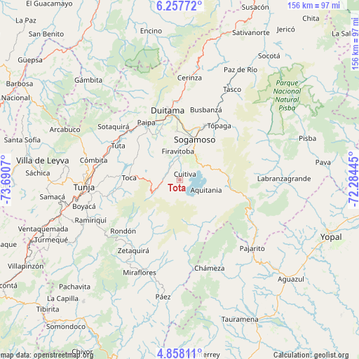
| Upper-left | 6.25772°, | -73.6907° |
| Center: | 5.55833°, | -72.98757° |
| Lower-right: | 4.85811°, | -72.28445° |
| Map W x H: | 155.6×155.6 km | = 96.7×96.7mi |
| max Lat: | 13.38166° ⇑48.9% North |
| Tota: | 5.55833° |
| min Lat: | ⇓51.1% South -4.21528° |
| min Long | Tota | max Long |
| -81.70636° | -72.98757° | -67.06996° |
| W 86.7%⇐ | ⇒13.3% E |
Elevation
Elevation of Tota is 2860 m = 9383 ft, and this is 1710.7 m = 5613 ft above average elevation for this country.
| Max E: |
3342 m = 10965 ft | 2.2% |
| Tota | 2860 m 9383 ft | |
| Avg. | 1149.3 m = 3771 ft | |
Min E: |
1 m = 3 ft | 97.8% |
See also: Colombia elevation on elevation.city.
Geographical zone
Tota is located in North Torrid zone (between Equator and Tropic of Cancer). Distance of Equator is 618 km =384 mi to South.| Distance of | km | miles | from Tota |
|---|---|---|---|
| North Pole | 9389 | 5834.1 | to North |
| Arctic Circle | 6783.1 | 4214.8 | to North |
| Tropic Cancer | 1987.9 | 1235.2 | to North |
| Equator | 618 | 384 | to South |


Nearby cities:
15 places around Tota: (largest is in red/bold)
• Aquitania
12.3 km =7.6 mi,  111°
111°
• Cuítiva
3.3 km =2.1 mi,  43°
43°
• Duitama
30 km =18.6 mi,  350°
350°
• Firavitoba
12.3 km =7.6 mi,  357°
357°
• Iza
6 km =3.7 mi,  8°
8°
• Mongua
29.6 km =18.4 mi, 43°
• Monguí
23.7 km =14.7 mi, 40°
• Nobsa
24.1 km =15 mi, 12°
• Paipa
28.5 km =17.7 mi,  329°
329°
• Pesca
7 km =4.3 mi,  262°
262°
• Siachoque
28.9 km =18 mi, 259°
• Sogamoso
18.3 km =11.4 mi,  18°
18°
• Tibasosa
21.4 km =13.3 mi, 356°
• Toca
21.7 km =13.5 mi,  271°
271°
• Tópaga
28.7 km =17.8 mi, 38°
Sources, notices
• [Note1] Compared only with cities in Colombia existing in our database
• [Src1] Map data: © OpenStreetMap contributors (CC-BY-SA)
• [Src2] Other city data from geonames.org with taken over terms of usage.
• [Src3] Geographical zone / Annual Mean Temperature by Robert A. Rohde @ Wikipedia
