Paipa geodata
Paipa (Boyacá) is a seat of a second-order administrative division; located in Colombia in America/Bogota (GMT-5) time zone. With population of 13,554 people, there are 237 cities with bigger population in this country. Compared to other cities in Colombia, 55.6% of cities are located further ↓South; 84.5% of cities are located further ←West and 89.1% of cities have lower elevation than Paipa. Note1


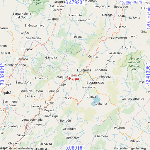
Paipa GPS coordinates[2]
5° 46' 48.468" North, 73° 7' 1.488" West
| Map corner | latitude | longitude |
|---|---|---|
| Upper-left | 6.47923°, | -73.82021° |
| Center: | 5.78013°, | -73.11708° |
| Lower-right: | 5.08016°, | -72.41396° |
| Map W x H: | 155.6×155.6 km | = 96.7×96.7mi |
| max Lat: | 13.38166° ⇑44.4% North |
| Paipa: | 5.78013° |
| min Lat: | ⇓55.6% South -4.21528° |
| min Long | Paipa | max Long |
| -81.70636° | -73.11708° | -67.06996° |
| W 84.5%⇐ | ⇒15.5% E |
Elevation
Elevation of Paipa is 2508 m = 8228 ft, and this is 1358.7 m = 4458 ft above average elevation for this country.
| Max E: |
3342 m = 10965 ft | 10.9% |
| Paipa | 2508 m 8228 ft | |
| Avg. | 1149.3 m = 3771 ft | |
Min E: |
1 m = 3 ft | 89.1% |
See also: Colombia elevation on elevation.city.
Geographical zone
Paipa is located in North Torrid zone (between Equator and Tropic of Cancer). Distance of Equator is 642.7 km =399.4 mi to South.| Distance of | km | miles | from Paipa |
|---|---|---|---|
| North Pole | 9364.4 | 5818.8 | to North |
| Arctic Circle | 6758.5 | 4199.5 | to North |
| Tropic Cancer | 1963.2 | 1219.9 | to North |
| Equator | 642.7 | 399.4 | to South |


Nearby cities:
15 places around Paipa: (largest is in red/bold)
• Busbanzá
26.4 km =16.4 mi,  77°
77°
• Cerinza
27 km =16.8 mi,  43°
43°
• Combita
27.5 km =17.1 mi,  233°
233°
• Duitama
10.4 km =6.5 mi,  61°
61°
• Firavitoba
18.5 km =11.5 mi,  132°
132°
• Floresta
23.6 km =14.7 mi,  68°
68°
• Iza
24.1 km =15 mi,  140°
140°
• Nobsa
19.5 km =12.1 mi,  93°
93°
• Pesca
26.6 km =16.5 mi,  163°
163°
• Santa Rosa de Viterbo
18.2 km =11.3 mi, 55°
• Sogamoso
21.5 km =13.4 mi,  109°
109°
• Sotaquirá
14.5 km =9 mi,  263°
263°
• Tibasosa
13.4 km =8.3 mi,  104°
104°
• Toca
25.2 km =15.7 mi,  197°
197°
• Tuta
15.8 km =9.8 mi, 230°
Sources, notices
• [Note1] Compared only with cities in Colombia existing in our database
• [Src1] Map data: © OpenStreetMap contributors (CC-BY-SA)
• [Src2] Other city data from geonames.org with taken over terms of usage.
• [Src3] Geographical zone / Annual Mean Temperature by Robert A. Rohde @ Wikipedia
