Tibasosa geodata
Tibasosa (Boyacá) is a seat of a second-order administrative division; located in Colombia in America/Bogota (GMT-5) time zone. With population of 3,535 people, there are 629 cities with bigger population in this country. Compared to other cities in Colombia, 54.9% of cities are located further ↓South; 86.5% of cities are located further ←West and 89% of cities have lower elevation than Tibasosa. Note1


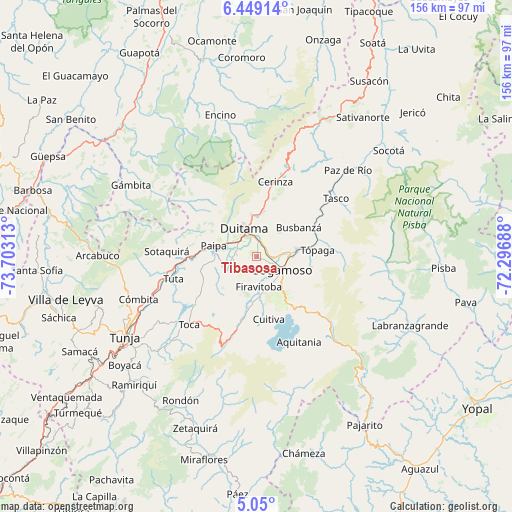
Tibasosa GPS coordinates[2]
5° 45' 0" North, 73° 0' 0" West
| Map corner | latitude | longitude |
|---|---|---|
| Upper-left | 6.44914°, | -73.70313° |
| Center: | 5.75°, | -73° |
| Lower-right: | 5.05°, | -72.29688° |
| Map W x H: | 155.6×155.6 km | = 96.7×96.7mi |
| max Lat: | 13.38166° ⇑45.1% North |
| Tibasosa: | 5.75° |
| min Lat: | ⇓54.9% South -4.21528° |
| min Long | Tibasosa | max Long |
| -81.70636° | -73° | -67.06996° |
| W 86.5%⇐ | ⇒13.5% E |
Elevation
Elevation of Tibasosa is 2504 m = 8215 ft, and this is 1354.7 m = 4445 ft above average elevation for this country.
| Max E: |
3342 m = 10965 ft | 11% |
| Tibasosa | 2504 m 8215 ft | |
| Avg. | 1149.3 m = 3771 ft | |
Min E: |
1 m = 3 ft | 89% |
See also: Colombia elevation on elevation.city.
Geographical zone
Tibasosa is located in North Torrid zone (between Equator and Tropic of Cancer). Distance of Equator is 639.3 km =397.2 mi to South.| Distance of | km | miles | from Tibasosa |
|---|---|---|---|
| North Pole | 9367.7 | 5820.8 | to North |
| Arctic Circle | 6761.8 | 4201.6 | to North |
| Tropic Cancer | 1966.6 | 1222 | to North |
| Equator | 639.3 | 397.2 | to South |


Nearby cities:
15 places around Tibasosa: (largest is in red/bold)
• Busbanzá
15.6 km =9.7 mi,  55°
55°
• Corrales
19.5 km =12.1 mi, 62°
• Cuítiva
19.2 km =11.9 mi,  169°
169°
• Duitama
9.1 km =5.7 mi,  335°
335°
• Firavitoba
9.1 km =5.7 mi,  175°
175°
• Floresta
15.1 km =9.4 mi,  36°
36°
• Iza
15.5 km =9.6 mi, 171°
• Mongua
21.8 km =13.5 mi,  89°
89°
• Monguí
17 km =10.6 mi,  100°
100°
• Nobsa
6.9 km =4.3 mi,  71°
71°
• Paipa
13.4 km =8.3 mi,  284°
284°
• Santa Rosa de Viterbo
13.9 km =8.6 mi,  8°
8°
• Sogamoso
8.3 km =5.2 mi,  118°
118°
• Tota
21.4 km =13.3 mi, 176°
• Tópaga
19.3 km =12 mi, 86°
Sources, notices
• [Note1] Compared only with cities in Colombia existing in our database
• [Src1] Map data: © OpenStreetMap contributors (CC-BY-SA)
• [Src2] Other city data from geonames.org with taken over terms of usage.
• [Src3] Geographical zone / Annual Mean Temperature by Robert A. Rohde @ Wikipedia
