Iza geodata
Iza (Boyacá) is a seat of a second-order administrative division; located in Colombia in America/Bogota (GMT-5) time zone. With population of 748 people, there are 991 cities with bigger population in this country. Compared to other cities in Colombia, 52.3% of cities are located further ↓South; 86.9% of cities are located further ←West and 89.4% of cities have lower elevation than Iza. Note1


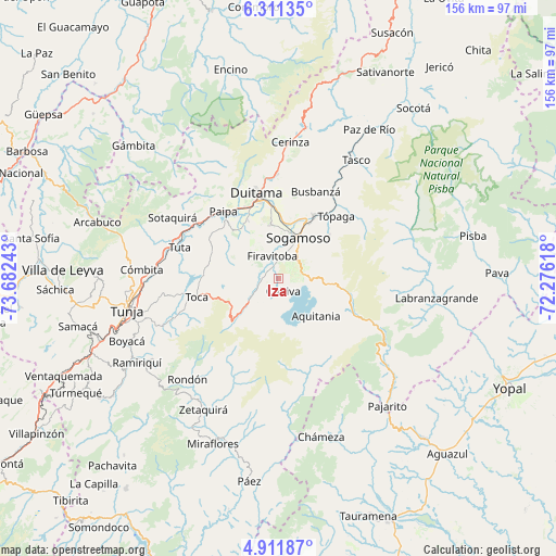
Iza GPS coordinates[2]
5° 36' 43.308" North, 72° 58' 45.48" West
| Map corner | latitude | longitude |
|---|---|---|
| Upper-left | 6.31135°, | -73.68243° |
| Center: | 5.61203°, | -72.9793° |
| Lower-right: | 4.91187°, | -72.27618° |
| Map W x H: | 155.6×155.6 km | = 96.7×96.7mi |
| max Lat: | 13.38166° ⇑47.7% North |
| Iza: | 5.61203° |
| min Lat: | ⇓52.3% South -4.21528° |
| min Long | Iza | max Long |
| -81.70636° | -72.9793° | -67.06996° |
| W 86.9%⇐ | ⇒13.1% E |
Elevation
Elevation of Iza is 2531 m = 8304 ft, and this is 1381.7 m = 4533 ft above average elevation for this country.
| Max E: |
3342 m = 10965 ft | 10.6% |
| Iza | 2531 m 8304 ft | |
| Avg. | 1149.3 m = 3771 ft | |
Min E: |
1 m = 3 ft | 89.4% |
See also: Colombia elevation on elevation.city.
Geographical zone
Iza is located in North Torrid zone (between Equator and Tropic of Cancer). Distance of Equator is 624 km =387.7 mi to South.| Distance of | km | miles | from Iza |
|---|---|---|---|
| North Pole | 9383.1 | 5830.4 | to North |
| Arctic Circle | 6777.2 | 4211.2 | to North |
| Tropic Cancer | 1981.9 | 1231.5 | to North |
| Equator | 624 | 387.7 | to South |


Nearby cities:
15 places around Iza: (largest is in red/bold)
• Aquitania
14.8 km =9.2 mi,  134°
134°
• Busbanzá
26.5 km =16.5 mi,  23°
23°
• Cuítiva
3.8 km =2.4 mi,  158°
158°
• Duitama
24.4 km =15.2 mi,  345°
345°
• Firavitoba
6.5 km =4 mi, 346°
• Mongua
24.8 km =15.4 mi,  51°
51°
• Monguí
18.9 km =11.7 mi, 49°
• Nobsa
18 km =11.2 mi,  13°
13°
• Paipa
24.1 km =15 mi,  320°
320°
• Pesca
10.4 km =6.5 mi,  228°
228°
• Sogamoso
12.4 km =7.7 mi, 23°
• Tibasosa
15.5 km =9.6 mi, 351°
• Toca
23.3 km =14.5 mi,  256°
256°
• Tota
6 km =3.7 mi,  188°
188°
• Tópaga
23.6 km =14.7 mi, 45°
Sources, notices
• [Note1] Compared only with cities in Colombia existing in our database
• [Src1] Map data: © OpenStreetMap contributors (CC-BY-SA)
• [Src2] Other city data from geonames.org with taken over terms of usage.
• [Src3] Geographical zone / Annual Mean Temperature by Robert A. Rohde @ Wikipedia
