Sogamoso geodata
Sogamoso (Boyacá) is a seat of a second-order administrative division; located in Colombia in America/Bogota (GMT-5) time zone. With population of 126,551 people, there are 34 cities with bigger population in this country. Compared to other cities in Colombia, 54.2% of cities are located further ↓South; 88% of cities are located further ←West and 88.4% of cities have lower elevation than Sogamoso. Note1


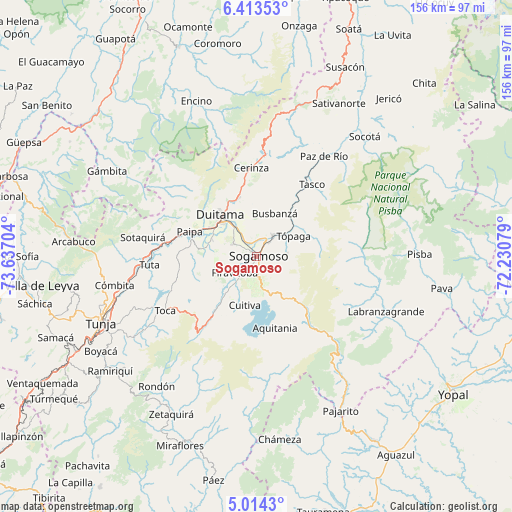
Sogamoso GPS coordinates[2]
5° 42' 51.624" North, 72° 56' 2.076" West
| Map corner | latitude | longitude |
|---|---|---|
| Upper-left | 6.41353°, | -73.63704° |
| Center: | 5.71434°, | -72.93391° |
| Lower-right: | 5.0143°, | -72.23079° |
| Map W x H: | 155.6×155.6 km | = 96.7×96.7mi |
| max Lat: | 13.38166° ⇑45.8% North |
| Sogamoso: | 5.71434° |
| min Lat: | ⇓54.2% South -4.21528° |
| min Long | Sogamoso | max Long |
| -81.70636° | -72.93391° | -67.06996° |
| W 88%⇐ | ⇒12% E |
Elevation
Elevation of Sogamoso is 2490 m = 8169 ft, and this is 1340.7 m = 4399 ft above average elevation for this country.
| Max E: |
3342 m = 10965 ft | 11.6% |
| Sogamoso | 2490 m 8169 ft | |
| Avg. | 1149.3 m = 3771 ft | |
Min E: |
1 m = 3 ft | 88.4% |
See also: Sogamoso elevation on elevation.city.
Geographical zone
Sogamoso is located in North Torrid zone (between Equator and Tropic of Cancer). Distance of Equator is 635.4 km =394.8 mi to South.| Distance of | km | miles | from Sogamoso |
|---|---|---|---|
| North Pole | 9371.7 | 5823.3 | to North |
| Arctic Circle | 6765.8 | 4204.1 | to North |
| Tropic Cancer | 1970.5 | 1224.4 | to North |
| Equator | 635.4 | 394.8 | to South |


Nearby cities:
15 places around Sogamoso: (largest is in red/bold)
• Busbanzá
14 km =8.7 mi,  23°
23°
• Corrales
16.3 km =10.1 mi,  38°
38°
• Cuítiva
15.4 km =9.6 mi,  193°
193°
• Duitama
16.5 km =10.3 mi,  317°
317°
• Firavitoba
8.3 km =5.2 mi,  232°
232°
• Floresta
16.2 km =10.1 mi,  5°
5°
• Gámeza
17.2 km =10.7 mi,  55°
55°
• Iza
12.4 km =7.7 mi,  203°
203°
• Mongua
15 km =9.3 mi,  74°
74°
• Monguí
9.4 km =5.8 mi,  85°
85°
• Nobsa
6.2 km =3.9 mi,  352°
352°
• Santa Rosa de Viterbo
18.5 km =11.5 mi,  343°
343°
• Tibasosa
8.3 km =5.2 mi,  298°
298°
• Tota
18.3 km =11.4 mi, 198°
• Tópaga
13 km =8.1 mi, 67°
Sources, notices
• [Note1] Compared only with cities in Colombia existing in our database
• [Src1] Map data: © OpenStreetMap contributors (CC-BY-SA)
• [Src2] Other city data from geonames.org with taken over terms of usage.
• [Src3] Geographical zone / Annual Mean Temperature by Robert A. Rohde @ Wikipedia
