Cartago geodata
Cartago (Valle del Cauca) is a seat of a second-order administrative division; located in Colombia in America/Bogota (GMT-5) time zone. With population of 134,827 people, there are 30 cities with bigger population in this country. Compared to other cities in Colombia, 67.4% of cities are located further ↑North; 78.4% of cities are located further →East and 57.6% of cities have higher elevation than Cartago. Note1


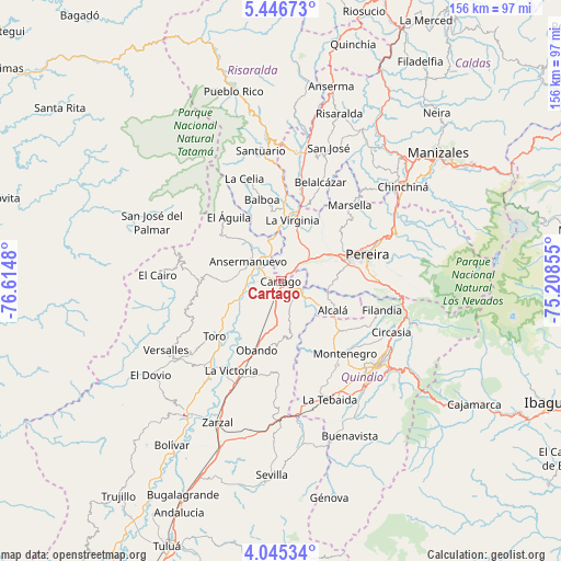
Cartago GPS coordinates[2]
4° 44' 47.004" North, 75° 54' 42.012" West
| Map corner | latitude | longitude |
|---|---|---|
| Upper-left | 5.44673°, | -76.6148° |
| Center: | 4.74639°, | -75.91167° |
| Lower-right: | 4.04534°, | -75.20855° |
| Map W x H: | 155.8×155.8 km | = 96.8×96.8mi |
| max Lat: | 13.38166° ⇑67.4% North |
| Cartago: | 4.74639° |
| min Lat: | ⇓32.6% South -4.21528° |
| min Long | Cartago | max Long |
| -81.70636° | -75.91167° | -67.06996° |
| W 21.6%⇐ | ⇒78.4% E |
Elevation
Elevation of Cartago is 915 m = 3002 ft, and this is 234.3 m = 769 ft below average elevation for this country.
| Max E: |
3342 m = 10965 ft | 57.6% |
| Avg. | 1149.3 m = 3771 ft | |
| Cartago | 915 m = 3002 ft | |
Min E: |
1 m = 3 ft | 42.4% |
See also: Cartago elevation on elevation.city.
Geographical zone
Cartago is located in North Torrid zone (between Equator and Tropic of Cancer). Distance of Equator is 527.7 km =327.9 mi to South.| Distance of | km | miles | from Cartago |
|---|---|---|---|
| North Pole | 9479.3 | 5890.2 | to North |
| Arctic Circle | 6873.4 | 4270.9 | to North |
| Tropic Cancer | 2078.2 | 1291.3 | to North |
| Equator | 527.7 | 327.9 | to South |


Nearby cities:
15 places around Cartago: (largest is in red/bold)
• Alcalá
16.4 km =10.2 mi,  119°
119°
• Ansermanuevo
10.8 km =6.7 mi,  301°
301°
• Argelia
23.1 km =14.4 mi,  263°
263°
• Balboa
23.2 km =14.4 mi,  347°
347°
• Dosquebradas
29 km =18 mi,  69°
69°
• El Águila
23.4 km =14.5 mi,  322°
322°
• La Victoria
28.4 km =17.6 mi,  209°
209°
• La Virginia
17.4 km =10.8 mi,  10°
10°
• Marsella
28.7 km =17.8 mi,  42°
42°
• Montenegro
26.8 km =16.7 mi,  138°
138°
• Obando
20.2 km =12.6 mi,  199°
199°
• Pereira
25 km =15.5 mi, 72°
• Quimbaya
21.5 km =13.4 mi,  129°
129°
• Toro
24 km =14.9 mi,  231°
231°
• Ulloa
19.6 km =12.2 mi,  103°
103°
Sources, notices
• [Note1] Compared only with cities in Colombia existing in our database
• [Src1] Map data: © OpenStreetMap contributors (CC-BY-SA)
• [Src2] Other city data from geonames.org with taken over terms of usage.
• [Src3] Geographical zone / Annual Mean Temperature by Robert A. Rohde @ Wikipedia
