Alcalá geodata
Alcalá (Valle del Cauca) is a seat of a second-order administrative division; located in Colombia in America/Bogota (GMT-5) time zone. With population of 9,135 people, there are 334 cities with bigger population in this country. Compared to other cities in Colombia, 68.8% of cities are located further ↑North; 74.6% of cities are located further →East and 52.9% of cities have lower elevation than Alcalá. Note1


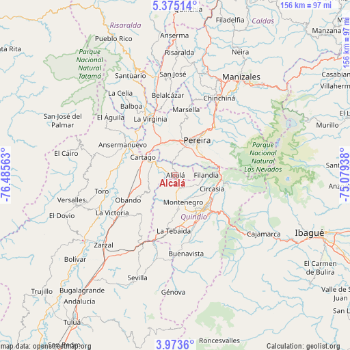
Alcalá GPS coordinates[2]
4° 40' 28.992" North, 75° 46' 57" West
| Map corner | latitude | longitude |
|---|---|---|
| Upper-left | 5.37514°, | -76.48563° |
| Center: | 4.67472°, | -75.7825° |
| Lower-right: | 3.9736°, | -75.07938° |
| Map W x H: | 155.8×155.8 km | = 96.8×96.8mi |
| max Lat: | 13.38166° ⇑68.8% North |
| Alcalá: | 4.67472° |
| min Lat: | ⇓31.2% South -4.21528° |
| min Long | Alcalá | max Long |
| -81.70636° | -75.7825° | -67.06996° |
| W 25.4%⇐ | ⇒74.6% E |
Elevation
Elevation of Alcalá is 1235 m = 4052 ft, and this is 85.7 m = 281 ft above average elevation for this country.
| Max E: |
3342 m = 10965 ft | 47.1% |
| Alcalá | 1235 m 4052 ft | |
| Avg. | 1149.3 m = 3771 ft | |
Min E: |
1 m = 3 ft | 52.9% |
See also: Colombia elevation on elevation.city.
Geographical zone
Alcalá is located in North Torrid zone (between Equator and Tropic of Cancer). Distance of Equator is 519.8 km =323 mi to South.| Distance of | km | miles | from Alcalá |
|---|---|---|---|
| North Pole | 9487.3 | 5895.1 | to North |
| Arctic Circle | 6881.4 | 4275.9 | to North |
| Tropic Cancer | 2086.1 | 1296.2 | to North |
| Equator | 519.8 | 323 | to South |


Nearby cities:
15 places around Alcalá: (largest is in red/bold)
• Ansermanuevo
27.2 km =16.9 mi,  300°
300°
• Armenia
19.3 km =12 mi,  144°
144°
• Calarcá
22.5 km =14 mi, 135°
• Cartago
16.4 km =10.2 mi, 299°
• Circasia
17.4 km =10.8 mi,  110°
110°
• Dosquebradas
22.3 km =13.9 mi,  34°
34°
• Filandia
13.8 km =8.6 mi,  90°
90°
• La Tebaida
24.7 km =15.3 mi,  181°
181°
• La Virginia
27.4 km =17 mi,  336°
336°
• Montenegro
12.5 km =7.8 mi,  163°
163°
• Obando
23.9 km =14.9 mi,  242°
242°
• Pereira
18.1 km =11.2 mi, 31°
• Quimbaya
6.1 km =3.8 mi, 159°
• Salento
23.9 km =14.9 mi,  99°
99°
• Ulloa
5.7 km =3.5 mi,  54°
54°
Sources, notices
• [Note1] Compared only with cities in Colombia existing in our database
• [Src1] Map data: © OpenStreetMap contributors (CC-BY-SA)
• [Src2] Other city data from geonames.org with taken over terms of usage.
• [Src3] Geographical zone / Annual Mean Temperature by Robert A. Rohde @ Wikipedia
