Sonsón geodata
Sonsón (Antioquia) is a seat of a second-order administrative division; located in Colombia in America/Bogota (GMT-5) time zone. With population of 17,232 people, there are 204 cities with bigger population in this country. Compared to other cities in Colombia, 54.1% of cities are located further ↓South; 61.8% of cities are located further →East and 88.6% of cities have lower elevation than Sonsón. Note1


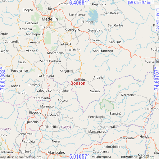
Sonsón GPS coordinates[2]
5° 42' 38.232" North, 75° 18' 38.484" West
| Map corner | latitude | longitude |
|---|---|---|
| Upper-left | 6.40981°, | -76.01382° |
| Center: | 5.71062°, | -75.31069° |
| Lower-right: | 5.01057°, | -74.60757° |
| Map W x H: | 155.6×155.6 km | = 96.7×96.7mi |
| max Lat: | 13.38166° ⇑45.9% North |
| Sonsón: | 5.71062° |
| min Lat: | ⇓54.1% South -4.21528° |
| min Long | Sonsón | max Long |
| -81.70636° | -75.31069° | -67.06996° |
| W 38.2%⇐ | ⇒61.8% E |
Elevation
Elevation of Sonsón is 2493 m = 8179 ft, and this is 1343.7 m = 4408 ft above average elevation for this country.
| Max E: |
3342 m = 10965 ft | 11.4% |
| Sonsón | 2493 m 8179 ft | |
| Avg. | 1149.3 m = 3771 ft | |
Min E: |
1 m = 3 ft | 88.6% |
See also: Colombia elevation on elevation.city.
Geographical zone
Sonsón is located in North Torrid zone (between Equator and Tropic of Cancer). Distance of Equator is 635 km =394.6 mi to South.| Distance of | km | miles | from Sonsón |
|---|---|---|---|
| North Pole | 9372.1 | 5823.6 | to North |
| Arctic Circle | 6766.2 | 4204.3 | to North |
| Tropic Cancer | 1971 | 1224.7 | to North |
| Equator | 635 | 394.6 | to South |


Nearby cities:
15 places around Sonsón: (largest is in red/bold)
• Abejorral
15.6 km =9.7 mi,  304°
304°
• Aguadas
19.5 km =12.1 mi,  235°
235°
• Argelia
18.7 km =11.6 mi,  82°
82°
• El Carmen
25.5 km =15.8 mi,  39°
39°
• La Ceja
38.2 km =23.7 mi,  339°
339°
• La Pintada
33 km =20.5 mi,  277°
277°
• La Unión
29.9 km =18.6 mi,  349°
349°
• Montebello
35.7 km =22.2 mi,  317°
317°
• Nariño
18.7 km =11.6 mi,  127°
127°
• Pensilvania
40 km =24.9 mi,  155°
155°
• Pácora
26.2 km =16.3 mi,  218°
218°
• Salamina
39 km =24.2 mi,  210°
210°
• San Francisco
36.5 km =22.7 mi, 39°
• Santa Bárbara
33.7 km =20.9 mi, 302°
• Valparaíso
36.3 km =22.6 mi,  252°
252°
Sources, notices
• [Note1] Compared only with cities in Colombia existing in our database
• [Src1] Map data: © OpenStreetMap contributors (CC-BY-SA)
• [Src2] Other city data from geonames.org with taken over terms of usage.
• [Src3] Geographical zone / Annual Mean Temperature by Robert A. Rohde @ Wikipedia
