Repelón geodata
Repelón (Atlántico) is a seat of a second-order administrative division; located in Colombia in America/Bogota (GMT-5) time zone. With population of 18,685 people, there are 193 cities with bigger population in this country. Compared to other cities in Colombia, 96.2% of cities are located further ↓South; 57.1% of cities are located further →East and 95.6% of cities have higher elevation than Repelón. Note1


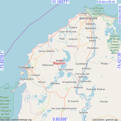
Repelón GPS coordinates[2]
10° 29' 42.72" North, 75° 7' 28.128" West
| Map corner | latitude | longitude |
|---|---|---|
| Upper-left | 11.18577°, | -75.82761° |
| Center: | 10.4952°, | -75.12448° |
| Lower-right: | 9.80308°, | -74.42136° |
| Map W x H: | 153.7×153.7 km | = 95.5×95.5mi |
| max Lat: | 13.38166° ⇑3.8% North |
| Repelón: | 10.4952° |
| min Lat: | ⇓96.2% South -4.21528° |
| min Long | Repelón | max Long |
| -81.70636° | -75.12448° | -67.06996° |
| W 42.9%⇐ | ⇒57.1% E |
Elevation
Elevation of Repelón is 11 m = 36 ft, and this is 1138.3 m = 3735 ft below average elevation for this country.
| Max E: |
3342 m = 10965 ft | 95.6% |
| Avg. | 1149.3 m = 3771 ft | |
| Repelón | 11 m = 36 ft | |
Min E: |
1 m = 3 ft | 4.4% |
See also: Colombia elevation on elevation.city.
Geographical zone
Repelón is located in North Torrid zone (between Equator and Tropic of Cancer). Distance of Equator is 1167 km =725.1 mi to South.| Distance of | km | miles | from Repelón |
|---|---|---|---|
| North Pole | 8840.1 | 5493 | to North |
| Arctic Circle | 6234.2 | 3873.8 | to North |
| Tropic Cancer | 1439 | 894.2 | to North |
| Equator | 1167 | 725.1 | to South |


Nearby cities:
15 places around Repelón: (largest is in red/bold)
• Arroyohondo
29.3 km =18.2 mi,  157°
157°
• Campo de la Cruz
29.4 km =18.3 mi,  116°
116°
• Candelaria
27.1 km =16.8 mi,  98°
98°
• Clemencia
23.3 km =14.5 mi,  289°
289°
• Luruaco
13.9 km =8.6 mi,  347°
347°
• Manatí
18.9 km =11.7 mi,  106°
106°
• Piojó
28.2 km =17.5 mi,  3°
3°
• Sabanalarga
26.8 km =16.7 mi,  55°
55°
• San Cristóbal
12.8 km =8 mi,  149°
149°
• San Estanislao
11.2 km =7 mi,  195°
195°
• Santa Catalina
21.6 km =13.4 mi,  303°
303°
• Santa Lucía
26.2 km =16.3 mi,  136°
136°
• Santa Rosa
27.4 km =17 mi,  258°
258°
• Soplaviento
11.5 km =7.1 mi,  188°
188°
• Villanueva
17.2 km =10.7 mi,  250°
250°
Sources, notices
• [Note1] Compared only with cities in Colombia existing in our database
• [Src1] Map data: © OpenStreetMap contributors (CC-BY-SA)
• [Src2] Other city data from geonames.org with taken over terms of usage.
• [Src3] Geographical zone / Annual Mean Temperature by Robert A. Rohde @ Wikipedia
