San Pelayo geodata
San Pelayo (Córdoba) is a seat of a second-order administrative division; located in Colombia in America/Bogota (GMT-5) time zone. With population of 5,637 people, there are 468 cities with bigger population in this country. Compared to other cities in Colombia, 86.8% of cities are located further ↓South; 76.9% of cities are located further →East and 95.6% of cities have higher elevation than San Pelayo. Note1


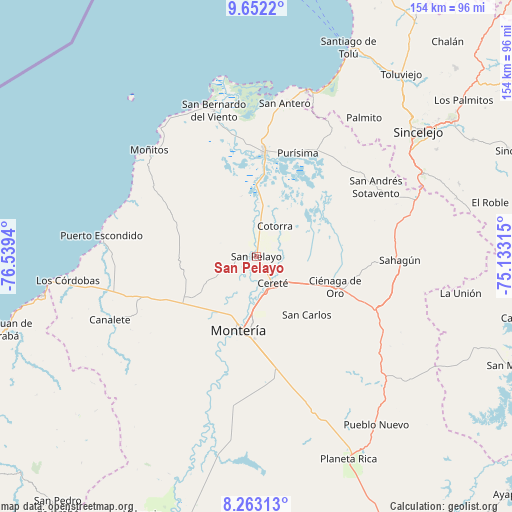
San Pelayo GPS coordinates[2]
8° 57' 29.988" North, 75° 50' 10.572" West
| Map corner | latitude | longitude |
|---|---|---|
| Upper-left | 9.6522°, | -76.5394° |
| Center: | 8.95833°, | -75.83627° |
| Lower-right: | 8.26313°, | -75.13315° |
| Map W x H: | 154.5×154.5 km | = 96×96mi |
| max Lat: | 13.38166° ⇑13.2% North |
| San Pelayo: | 8.95833° |
| min Lat: | ⇓86.8% South -4.21528° |
| min Long | San Pelayo | max Long |
| -81.70636° | -75.83627° | -67.06996° |
| W 23.1%⇐ | ⇒76.9% E |
Elevation
Elevation of San Pelayo is 11 m = 36 ft, and this is 1138.3 m = 3735 ft below average elevation for this country.
| Max E: |
3342 m = 10965 ft | 95.6% |
| Avg. | 1149.3 m = 3771 ft | |
| San Pelayo | 11 m = 36 ft | |
Min E: |
1 m = 3 ft | 4.4% |
See also: Colombia elevation on elevation.city.
Geographical zone
San Pelayo is located in North Torrid zone (between Equator and Tropic of Cancer). Distance of Equator is 996.1 km =618.9 mi to South.| Distance of | km | miles | from San Pelayo |
|---|---|---|---|
| North Pole | 9011 | 5599.2 | to North |
| Arctic Circle | 6405.1 | 3979.9 | to North |
| Tropic Cancer | 1609.8 | 1000.3 | to North |
| Equator | 996.1 | 618.9 | to South |


Nearby cities:
15 places around San Pelayo: (largest is in red/bold)
• Buenavista
20.9 km =13 mi,  299°
299°
• Cereté
9.6 km =6 mi,  148°
148°
• Chimá
31.1 km =19.3 mi,  47°
47°
• Ciénaga de Oro
25.5 km =15.8 mi,  111°
111°
• Cotorra
10.3 km =6.4 mi,  29°
29°
• Lorica
31 km =19.3 mi,  4°
4°
• Momil
35.8 km =22.2 mi, 29°
• Montería
23.9 km =14.9 mi,  191°
191°
• Moñitos
45.4 km =28.2 mi,  314°
314°
• Purísima de la Concepción
33.4 km =20.8 mi,  22°
22°
• Sahagún
43.2 km =26.8 mi,  91°
91°
• San Andrés de Sotavento
41.5 km =25.8 mi,  60°
60°
• San Carlos
23.5 km =14.6 mi,  140°
140°
• San Carlos
27.4 km =17 mi, 150°
• Tuchín
40 km =24.9 mi, 50°
Sources, notices
• [Note1] Compared only with cities in Colombia existing in our database
• [Src1] Map data: © OpenStreetMap contributors (CC-BY-SA)
• [Src2] Other city data from geonames.org with taken over terms of usage.
• [Src3] Geographical zone / Annual Mean Temperature by Robert A. Rohde @ Wikipedia
