Montería geodata
Montería (Córdoba) is a seat of a first-order administrative division; located in Colombia in America/Bogota (GMT-5) time zone. With population of 272,420 people, there are 20 cities with bigger population in this country. Compared to other cities in Colombia, 85.1% of cities are located further ↓South; 77.6% of cities are located further →East and 93.2% of cities have higher elevation than Montería. Note1


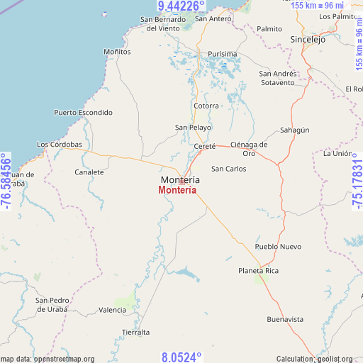
Montería GPS coordinates[2]
8° 44' 52.728" North, 75° 52' 53.148" West
| Map corner | latitude | longitude |
|---|---|---|
| Upper-left | 9.44226°, | -76.58456° |
| Center: | 8.74798°, | -75.88143° |
| Lower-right: | 8.0524°, | -75.17831° |
| Map W x H: | 154.5×154.5 km | = 96×96mi |
| max Lat: | 13.38166° ⇑14.9% North |
| Montería: | 8.74798° |
| min Lat: | ⇓85.1% South -4.21528° |
| min Long | Montería | max Long |
| -81.70636° | -75.88143° | -67.06996° |
| W 22.4%⇐ | ⇒77.6% E |
Elevation
Elevation of Montería is 19 m = 62 ft, and this is 1130.3 m = 3708 ft below average elevation for this country.
| Max E: |
3342 m = 10965 ft | 93.2% |
| Avg. | 1149.3 m = 3771 ft | |
| Montería | 19 m = 62 ft | |
Min E: |
1 m = 3 ft | 6.8% |
See also: Montería elevation on elevation.city.
Geographical zone
Montería is located in North Torrid zone (between Equator and Tropic of Cancer). Distance of Equator is 972.7 km =604.4 mi to South.| Distance of | km | miles | from Montería |
|---|---|---|---|
| North Pole | 9034.4 | 5613.7 | to North |
| Arctic Circle | 6428.5 | 3994.5 | to North |
| Tropic Cancer | 1633.2 | 1014.8 | to North |
| Equator | 972.7 | 604.4 | to South |


Nearby cities:
15 places around Montería: (largest is in red/bold)
• Buenavista
36.1 km =22.4 mi,  338°
338°
• Canalete
36.4 km =22.6 mi,  257°
257°
• Canalete
39.7 km =24.7 mi,  276°
276°
• Cereté
18.2 km =11.3 mi,  33°
33°
• Chimá
52.5 km =32.6 mi, 31°
• Ciénaga de Oro
32 km =19.9 mi,  63°
63°
• Cotorra
33.9 km =21.1 mi,  17°
17°
• Los Córdobas
54.5 km =33.9 mi,  287°
287°
• Planeta Rica
49.6 km =30.8 mi,  138°
138°
• Pueblo Nuevo
49.4 km =30.7 mi,  123°
123°
• Puerto Escondido
51.7 km =32.1 mi,  305°
305°
• Sahagún
53 km =32.9 mi,  65°
65°
• San Carlos
18.5 km =11.5 mi,  91°
91°
• San Carlos
20.7 km =12.9 mi,  75°
75°
• San Pelayo
23.9 km =14.9 mi,  11°
11°
Sources, notices
• [Note1] Compared only with cities in Colombia existing in our database
• [Src1] Map data: © OpenStreetMap contributors (CC-BY-SA)
• [Src2] Other city data from geonames.org with taken over terms of usage.
• [Src3] Geographical zone / Annual Mean Temperature by Robert A. Rohde @ Wikipedia
