Ramiriquí geodata
Ramiriquí (Boyacá) is a seat of a second-order administrative division; located in Colombia in America/Bogota (GMT-5) time zone. With population of 5,039 people, there are 505 cities with bigger population in this country. Compared to other cities in Colombia, 52.6% of cities are located further ↑North; 79.5% of cities are located further ←West and 85.5% of cities have lower elevation than Ramiriquí. Note1


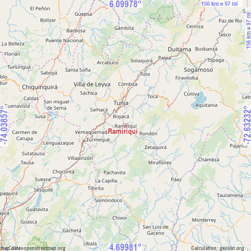
Ramiriquí GPS coordinates[2]
5° 24' 0.72" North, 73° 20' 7.584" West
| Map corner | latitude | longitude |
|---|---|---|
| Upper-left | 6.09978°, | -74.03857° |
| Center: | 5.4002°, | -73.33544° |
| Lower-right: | 4.69981°, | -72.63232° |
| Map W x H: | 155.7×155.7 km | = 96.7×96.7mi |
| max Lat: | 13.38166° ⇑52.6% North |
| Ramiriquí: | 5.4002° |
| min Lat: | ⇓47.4% South -4.21528° |
| min Long | Ramiriquí | max Long |
| -81.70636° | -73.33544° | -67.06996° |
| W 79.5%⇐ | ⇒20.5% E |
Elevation
Elevation of Ramiriquí is 2308 m = 7572 ft, and this is 1158.7 m = 3802 ft above average elevation for this country.
| Max E: |
3342 m = 10965 ft | 14.5% |
| Ramiriquí | 2308 m 7572 ft | |
| Avg. | 1149.3 m = 3771 ft | |
Min E: |
1 m = 3 ft | 85.5% |
See also: Colombia elevation on elevation.city.
Geographical zone
Ramiriquí is located in North Torrid zone (between Equator and Tropic of Cancer). Distance of Equator is 600.4 km =373.1 mi to South.| Distance of | km | miles | from Ramiriquí |
|---|---|---|---|
| North Pole | 9406.6 | 5845 | to North |
| Arctic Circle | 6800.7 | 4225.8 | to North |
| Tropic Cancer | 2005.5 | 1246.2 | to North |
| Equator | 600.4 | 373.1 | to South |


Nearby cities:
15 places around Ramiriquí: (largest is in red/bold)
• Boyacá
6.7 km =4.2 mi,  333°
333°
• Chivatá
18.5 km =11.5 mi,  18°
18°
• Ciénega
4.5 km =2.8 mi,  77°
77°
• Cucaita
20.7 km =12.9 mi,  320°
320°
• Jenesano
3.5 km =2.2 mi,  242°
242°
• Motavita
19.9 km =12.4 mi,  349°
349°
• Nuevo Colón
14.4 km =8.9 mi,  248°
248°
• Rondón
14.8 km =9.2 mi,  109°
109°
• Samacá
19.5 km =12.1 mi,  301°
301°
• Siachoque
16 km =9.9 mi,  38°
38°
• Soracá
11.2 km =7 mi,  1°
1°
• Tibaná
11.4 km =7.1 mi,  216°
216°
• Tunja
15.4 km =9.6 mi, 346°
• Turmequé
19.2 km =11.9 mi, 243°
• Viracachá
5.9 km =3.7 mi,  47°
47°
Sources, notices
• [Note1] Compared only with cities in Colombia existing in our database
• [Src1] Map data: © OpenStreetMap contributors (CC-BY-SA)
• [Src2] Other city data from geonames.org with taken over terms of usage.
• [Src3] Geographical zone / Annual Mean Temperature by Robert A. Rohde @ Wikipedia
