Boyacá geodata
Boyacá is a seat of a second-order administrative division; located in Colombia in America/Bogota (GMT-5) time zone. With population of 731 people, there are 995 cities with bigger population in this country. Compared to other cities in Colombia, 51.4% of cities are located further ↑North; 79% of cities are located further ←West and 87.3% of cities have lower elevation than Boyacá. Note1


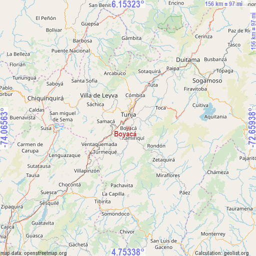
Boyacá GPS coordinates[2]
5° 27' 13.356" North, 73° 21' 45" West
| Map corner | latitude | longitude |
|---|---|---|
| Upper-left | 6.15323°, | -74.06563° |
| Center: | 5.45371°, | -73.3625° |
| Lower-right: | 4.75338°, | -72.65938° |
| Map W x H: | 155.6×155.7 km | = 96.7×96.7mi |
| max Lat: | 13.38166° ⇑51.4% North |
| Boyacá: | 5.45371° |
| min Lat: | ⇓48.6% South -4.21528° |
| min Long | Boyacá | max Long |
| -81.70636° | -73.3625° | -67.06996° |
| W 79%⇐ | ⇒21% E |
Elevation
Elevation of Boyacá is 2411 m = 7910 ft, and this is 1261.7 m = 4139 ft above average elevation for this country.
| Max E: |
3342 m = 10965 ft | 12.7% |
| Boyacá | 2411 m 7910 ft | |
| Avg. | 1149.3 m = 3771 ft | |
Min E: |
1 m = 3 ft | 87.3% |
See also: Colombia elevation on elevation.city.
Geographical zone
Boyacá is located in North Torrid zone (between Equator and Tropic of Cancer). Distance of Equator is 606.4 km =376.8 mi to South.| Distance of | km | miles | from Boyacá |
|---|---|---|---|
| North Pole | 9400.7 | 5841.3 | to North |
| Arctic Circle | 6794.8 | 4222.1 | to North |
| Tropic Cancer | 1999.5 | 1242.4 | to North |
| Equator | 606.4 | 376.8 | to South |


Nearby cities:
15 places around Boyacá: (largest is in red/bold)
• Chivatá
14.6 km =9.1 mi,  37°
37°
• Ciénega
8.9 km =5.5 mi,  124°
124°
• Cucaita
14.3 km =8.9 mi,  314°
314°
• Jenesano
7.6 km =4.7 mi,  180°
180°
• Motavita
13.7 km =8.5 mi,  357°
357°
• Nuevo Colón
15.2 km =9.4 mi,  223°
223°
• Oicatá
16.9 km =10.5 mi,  20°
20°
• Ramiriquí
6.7 km =4.2 mi,  153°
153°
• Samacá
14.3 km =8.9 mi,  287°
287°
• Siachoque
14.6 km =9.1 mi,  63°
63°
• Sora
15.7 km =9.8 mi,  321°
321°
• Soracá
6.1 km =3.8 mi,  32°
32°
• Tibaná
15.6 km =9.7 mi,  193°
193°
• Tunja
9.1 km =5.7 mi, 356°
• Viracachá
7.6 km =4.7 mi,  104°
104°
Sources, notices
• [Note1] Compared only with cities in Colombia existing in our database
• [Src1] Map data: © OpenStreetMap contributors (CC-BY-SA)
• [Src2] Other city data from geonames.org with taken over terms of usage.
• [Src3] Geographical zone / Annual Mean Temperature by Robert A. Rohde @ Wikipedia
