Rondón geodata
Rondón (Boyacá) is a seat of a second-order administrative division; located in Colombia in America/Bogota (GMT-5) time zone. With population of 504 people, there are 1028 cities with bigger population in this country. Compared to other cities in Colombia, 53.4% of cities are located further ↑North; 82.6% of cities are located further ←West and 81.3% of cities have lower elevation than Rondón. Note1


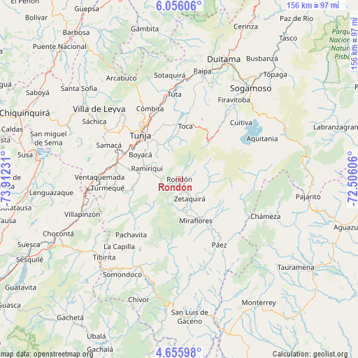
Rondón GPS coordinates[2]
5° 21' 23.112" North, 73° 12' 33.048" West
| Map corner | latitude | longitude |
|---|---|---|
| Upper-left | 6.05606°, | -73.91231° |
| Center: | 5.35642°, | -73.20918° |
| Lower-right: | 4.65598°, | -72.50606° |
| Map W x H: | 155.7×155.7 km | = 96.7×96.7mi |
| max Lat: | 13.38166° ⇑53.4% North |
| Rondón: | 5.35642° |
| min Lat: | ⇓46.6% South -4.21528° |
| min Long | Rondón | max Long |
| -81.70636° | -73.20918° | -67.06996° |
| W 82.6%⇐ | ⇒17.4% E |
Elevation
Elevation of Rondón is 2110 m = 6923 ft, and this is 960.7 m = 3152 ft above average elevation for this country.
| Max E: |
3342 m = 10965 ft | 18.7% |
| Rondón | 2110 m 6923 ft | |
| Avg. | 1149.3 m = 3771 ft | |
Min E: |
1 m = 3 ft | 81.3% |
See also: Colombia elevation on elevation.city.
Geographical zone
Rondón is located in North Torrid zone (between Equator and Tropic of Cancer). Distance of Equator is 595.6 km =370.1 mi to South.| Distance of | km | miles | from Rondón |
|---|---|---|---|
| North Pole | 9411.5 | 5848 | to North |
| Arctic Circle | 6805.6 | 4228.8 | to North |
| Tropic Cancer | 2010.3 | 1249.1 | to North |
| Equator | 595.6 | 370.1 | to South |


Nearby cities:
15 places around Rondón: (largest is in red/bold)
• Berbeo
17.1 km =10.6 mi,  147°
147°
• Boyacá
20.1 km =12.5 mi,  302°
302°
• Chivatá
23.8 km =14.8 mi,  340°
340°
• Ciénega
11.2 km =7 mi, 301°
• Jenesano
17.4 km =10.8 mi,  280°
280°
• Miraflores
19.2 km =11.9 mi,  158°
158°
• Ramiriquí
14.8 km =9.2 mi,  289°
289°
• San Eduardo
20.8 km =12.9 mi,  135°
135°
• Siachoque
17.8 km =11.1 mi,  347°
347°
• Soracá
21.1 km =13.1 mi,  319°
319°
• Tibaná
21.2 km =13.2 mi,  258°
258°
• Toca
23.2 km =14.4 mi,  6°
6°
• Tunja
26.5 km =16.5 mi, 318°
• Viracachá
13.1 km =8.1 mi,  312°
312°
• Zetaquira
9.4 km =5.8 mi, 151°
Sources, notices
• [Note1] Compared only with cities in Colombia existing in our database
• [Src1] Map data: © OpenStreetMap contributors (CC-BY-SA)
• [Src2] Other city data from geonames.org with taken over terms of usage.
• [Src3] Geographical zone / Annual Mean Temperature by Robert A. Rohde @ Wikipedia
