Tunja geodata
Tunja (Boyacá) is a seat of a first-order administrative division; located in Colombia in America/Bogota (GMT-5) time zone. With population of 117,479 people, there are 36 cities with bigger population in this country. Compared to other cities in Colombia, 50.3% of cities are located further ↓South; 78.6% of cities are located further ←West and 97.3% of cities have lower elevation than Tunja. Note1


Tunja GPS coordinates[2]
5° 32' 7.008" North, 73° 22' 4.008" West
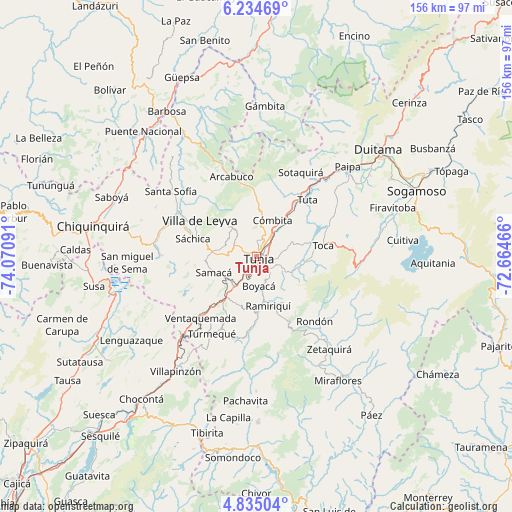
| Map corner | latitude | longitude |
|---|---|---|
| Upper-left | 6.23469°, | -74.07091° |
| Center: | 5.53528°, | -73.36778° |
| Lower-right: | 4.83504°, | -72.66466° |
| Map W x H: | 155.6×155.6 km | = 96.7×96.7mi |
| max Lat: | 13.38166° ⇑49.7% North |
| Tunja: | 5.53528° |
| min Lat: | ⇓50.3% South -4.21528° |
| min Long | Tunja | max Long |
| -81.70636° | -73.36778° | -67.06996° |
| W 78.6%⇐ | ⇒21.4% E |
Elevation
Elevation of Tunja is 2804 m = 9199 ft, and this is 1654.7 m = 5429 ft above average elevation for this country.
| Max E: |
3342 m = 10965 ft | 2.7% |
| Tunja | 2804 m 9199 ft | |
| Avg. | 1149.3 m = 3771 ft | |
Min E: |
1 m = 3 ft | 97.3% |
See also: Tunja elevation on elevation.city.
Geographical zone
Tunja is located in North Torrid zone (between Equator and Tropic of Cancer). Distance of Equator is 615.5 km =382.5 mi to South.| Distance of | km | miles | from Tunja |
|---|---|---|---|
| North Pole | 9391.6 | 5835.7 | to North |
| Arctic Circle | 6785.7 | 4216.4 | to North |
| Tropic Cancer | 1990.5 | 1236.8 | to North |
| Equator | 615.5 | 382.5 | to South |


Nearby cities:
15 places around Tunja: (largest is in red/bold)
• Boyacá
9.1 km =5.7 mi,  176°
176°
• Chivatá
9.8 km =6.1 mi,  74°
74°
• Chíquiza
15.1 km =9.4 mi,  300°
300°
• Ciénega
16.2 km =10.1 mi,  150°
150°
• Combita
12.3 km =7.6 mi,  27°
27°
• Cucaita
9.6 km =6 mi,  275°
275°
• Cómbita
11.9 km =7.4 mi,  24°
24°
• Motavita
4.6 km =2.9 mi,  1°
1°
• Oicatá
9.4 km =5.8 mi,  44°
44°
• Ramiriquí
15.4 km =9.6 mi,  166°
166°
• Samacá
13.8 km =8.6 mi,  250°
250°
• Siachoque
13.9 km =8.6 mi,  100°
100°
• Sora
9.7 km =6 mi,  290°
290°
• Soracá
5.5 km =3.4 mi,  135°
135°
• Viracachá
13.6 km =8.5 mi, 144°
Sources, notices
• [Note1] Compared only with cities in Colombia existing in our database
• [Src1] Map data: © OpenStreetMap contributors (CC-BY-SA)
• [Src2] Other city data from geonames.org with taken over terms of usage.
• [Src3] Geographical zone / Annual Mean Temperature by Robert A. Rohde @ Wikipedia
