Samacá geodata
Samacá (Boyacá) is a seat of a second-order administrative division; located in Colombia in America/Bogota (GMT-5) time zone. With population of 3,689 people, there are 613 cities with bigger population in this country. Compared to other cities in Colombia, 50.8% of cities are located further ↑North; 76% of cities are located further ←West and 93.1% of cities have lower elevation than Samacá. Note1


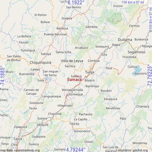
Samacá GPS coordinates[2]
5° 29' 33.828" North, 73° 29' 7.332" West
| Map corner | latitude | longitude |
|---|---|---|
| Upper-left | 6.1922°, | -74.1885° |
| Center: | 5.49273°, | -73.48537° |
| Lower-right: | 4.79244°, | -72.78225° |
| Map W x H: | 155.6×155.6 km | = 96.7×96.7mi |
| max Lat: | 13.38166° ⇑50.8% North |
| Samacá: | 5.49273° |
| min Lat: | ⇓49.2% South -4.21528° |
| min Long | Samacá | max Long |
| -81.70636° | -73.48537° | -67.06996° |
| W 76%⇐ | ⇒24% E |
Elevation
Elevation of Samacá is 2601 m = 8533 ft, and this is 1451.7 m = 4763 ft above average elevation for this country.
| Max E: |
3342 m = 10965 ft | 6.9% |
| Samacá | 2601 m 8533 ft | |
| Avg. | 1149.3 m = 3771 ft | |
Min E: |
1 m = 3 ft | 93.1% |
See also: Colombia elevation on elevation.city.
Geographical zone
Samacá is located in North Torrid zone (between Equator and Tropic of Cancer). Distance of Equator is 610.7 km =379.5 mi to South.| Distance of | km | miles | from Samacá |
|---|---|---|---|
| North Pole | 9396.3 | 5838.6 | to North |
| Arctic Circle | 6790.4 | 4219.4 | to North |
| Tropic Cancer | 1995.2 | 1239.8 | to North |
| Equator | 610.7 | 379.5 | to South |


Nearby cities:
15 places around Samacá: (largest is in red/bold)
• Boyacá
14.3 km =8.9 mi,  107°
107°
• Chíquiza
12.4 km =7.7 mi,  0°
0°
• Cucaita
6.6 km =4.1 mi,  31°
31°
• Jenesano
18 km =11.2 mi,  131°
131°
• Motavita
16.1 km =10 mi,  54°
54°
• Nuevo Colón
15.8 km =9.8 mi,  168°
168°
• Ramiriquí
19.5 km =12.1 mi,  121°
121°
• Ráquira
17 km =10.6 mi,  287°
287°
• Sora
8.9 km =5.5 mi, 25°
• Soracá
16.9 km =10.5 mi,  87°
87°
• Sáchica
12 km =7.5 mi,  328°
328°
• Tunja
13.8 km =8.6 mi,  70°
70°
• Turmequé
18.8 km =11.7 mi,  181°
181°
• Ventaquemada
14.5 km =9 mi,  195°
195°
• Villa de Leyva
16.3 km =10.1 mi,  344°
344°
Sources, notices
• [Note1] Compared only with cities in Colombia existing in our database
• [Src1] Map data: © OpenStreetMap contributors (CC-BY-SA)
• [Src2] Other city data from geonames.org with taken over terms of usage.
• [Src3] Geographical zone / Annual Mean Temperature by Robert A. Rohde @ Wikipedia
