Quinchía geodata
Quinchía (Risaralda) is a seat of a second-order administrative division; located in Colombia in America/Bogota (GMT-5) time zone. With population of 10,895 people, there are 283 cities with bigger population in this country. Compared to other cities in Colombia, 53.7% of cities are located further ↑North; 73.1% of cities are located further →East and 74.2% of cities have lower elevation than Quinchía. Note1


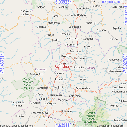
Quinchía GPS coordinates[2]
5° 20' 22.452" North, 75° 43' 48.648" West
| Map corner | latitude | longitude |
|---|---|---|
| Upper-left | 6.03923°, | -76.43331° |
| Center: | 5.33957°, | -75.73018° |
| Lower-right: | 4.63911°, | -75.02706° |
| Map W x H: | 155.7×155.7 km | = 96.7×96.7mi |
| max Lat: | 13.38166° ⇑53.7% North |
| Quinchía: | 5.33957° |
| min Lat: | ⇓46.3% South -4.21528° |
| min Long | Quinchía | max Long |
| -81.70636° | -75.73018° | -67.06996° |
| W 26.9%⇐ | ⇒73.1% E |
Elevation
Elevation of Quinchía is 1817 m = 5961 ft, and this is 667.7 m = 2191 ft above average elevation for this country.
| Max E: |
3342 m = 10965 ft | 25.8% |
| Quinchía | 1817 m 5961 ft | |
| Avg. | 1149.3 m = 3771 ft | |
Min E: |
1 m = 3 ft | 74.2% |
See also: Colombia elevation on elevation.city.
Geographical zone
Quinchía is located in North Torrid zone (between Equator and Tropic of Cancer). Distance of Equator is 593.7 km =368.9 mi to South.| Distance of | km | miles | from Quinchía |
|---|---|---|---|
| North Pole | 9413.4 | 5849.2 | to North |
| Arctic Circle | 6807.5 | 4230 | to North |
| Tropic Cancer | 2012.2 | 1250.3 | to North |
| Equator | 593.7 | 368.9 | to South |


Nearby cities:
15 places around Quinchía: (largest is in red/bold)
• Anserma
6.8 km =4.2 mi,  263°
263°
• Anserma
13.1 km =8.1 mi,  207°
207°
• Aranzazu
27.6 km =17.1 mi,  105°
105°
• Belén de Umbría
21.7 km =13.5 mi,  224°
224°
• Caramanta
25.1 km =15.6 mi,  22°
22°
• Filadelfia
19.3 km =12 mi,  104°
104°
• Guática
8 km =5 mi,  250°
250°
• La Merced
18.5 km =11.5 mi,  292°
292°
• La Merced
21.3 km =13.2 mi,  71°
71°
• Marmato
20.8 km =12.9 mi,  43°
43°
• Mistrató
17.7 km =11 mi, 254°
• Riosucio
9.6 km =6 mi, 18°
• Risaralda
19.7 km =12.2 mi,  191°
191°
• Salamina
27.9 km =17.3 mi, 74°
• Supía
15.4 km =9.6 mi,  34°
34°
Sources, notices
• [Note1] Compared only with cities in Colombia existing in our database
• [Src1] Map data: © OpenStreetMap contributors (CC-BY-SA)
• [Src2] Other city data from geonames.org with taken over terms of usage.
• [Src3] Geographical zone / Annual Mean Temperature by Robert A. Rohde @ Wikipedia
