Aranzazu geodata
Aranzazu (Caldas) is a seat of a second-order administrative division; located in Colombia in America/Bogota (GMT-5) time zone. With population of 9,327 people, there are 326 cities with bigger population in this country. Compared to other cities in Colombia, 55.7% of cities are located further ↑North; 66.1% of cities are located further →East and 76.4% of cities have lower elevation than Aranzazu. Note1


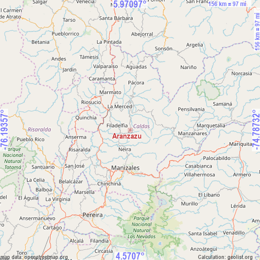
Aranzazu GPS coordinates[2]
5° 16' 16.428" North, 75° 29' 25.584" West
| Map corner | latitude | longitude |
|---|---|---|
| Upper-left | 5.97097°, | -76.19357° |
| Center: | 5.27123°, | -75.49044° |
| Lower-right: | 4.5707°, | -74.78732° |
| Map W x H: | 155.7×155.7 km | = 96.7×96.7mi |
| max Lat: | 13.38166° ⇑55.7% North |
| Aranzazu: | 5.27123° |
| min Lat: | ⇓44.3% South -4.21528° |
| min Long | Aranzazu | max Long |
| -81.70636° | -75.49044° | -67.06996° |
| W 33.9%⇐ | ⇒66.1% E |
Elevation
Elevation of Aranzazu is 1900 m = 6234 ft, and this is 750.7 m = 2463 ft above average elevation for this country.
| Max E: |
3342 m = 10965 ft | 23.6% |
| Aranzazu | 1900 m 6234 ft | |
| Avg. | 1149.3 m = 3771 ft | |
Min E: |
1 m = 3 ft | 76.4% |
See also: Colombia elevation on elevation.city.
Geographical zone
Aranzazu is located in North Torrid zone (between Equator and Tropic of Cancer). Distance of Equator is 586.1 km =364.2 mi to South.| Distance of | km | miles | from Aranzazu |
|---|---|---|---|
| North Pole | 9421 | 5853.9 | to North |
| Arctic Circle | 6815.1 | 4234.7 | to North |
| Tropic Cancer | 2019.8 | 1255 | to North |
| Equator | 586.1 | 364.2 | to South |


Nearby cities:
15 places around Aranzazu: (largest is in red/bold)
• Anserma
32.8 km =20.4 mi,  262°
262°
• Filadelfia
8.3 km =5.2 mi,  289°
289°
• La Merced
15.6 km =9.7 mi,  336°
336°
• Manizales
22.7 km =14.1 mi,  187°
187°
• Marmato
25.7 km =16 mi,  331°
331°
• Marulanda
25.5 km =15.8 mi,  86°
86°
• Neira
12.1 km =7.5 mi,  195°
195°
• Palestina
32.2 km =20 mi,  208°
208°
• Pácora
28.7 km =17.8 mi,  6°
6°
• Quinchía
27.6 km =17.1 mi, 285°
• Riosucio
28.9 km =18 mi,  305°
305°
• Risaralda
32.7 km =20.3 mi,  249°
249°
• Salamina
15.1 km =9.4 mi,  1°
1°
• Supía
26.9 km =16.7 mi,  318°
318°
• Villamaría
25.2 km =15.7 mi, 186°
Sources, notices
• [Note1] Compared only with cities in Colombia existing in our database
• [Src1] Map data: © OpenStreetMap contributors (CC-BY-SA)
• [Src2] Other city data from geonames.org with taken over terms of usage.
• [Src3] Geographical zone / Annual Mean Temperature by Robert A. Rohde @ Wikipedia
